
~ Crater Lake East OR topo map, 1:24000 scale, 7.5 X 7.5 Minute, Historical, 2011
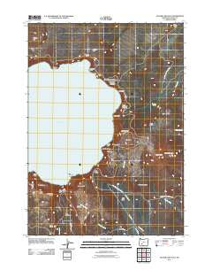
Crater Lake East, Oregon, USGS topographic map dated 2011.
Includes geographic coordinates (latitude and longitude). This topographic map is suitable for hiking, camping, and exploring, or framing it as a wall map.
Printed on-demand using high resolution imagery, on heavy weight and acid free paper, or alternatively on a variety of synthetic materials.
Topos available on paper, Waterproof, Poly, or Tyvek. Usually shipping rolled, unless combined with other folded maps in one order.
- Product Number: USGS-5411772
- Free digital map download (high-resolution, GeoPDF): Crater Lake East, Oregon (file size: 20 MB)
- Map Size: please refer to the dimensions of the GeoPDF map above
- Weight (paper map): ca. 55 grams
- Map Type: POD USGS Topographic Map
- Map Series: US Topo
- Map Verison: Historical
- Cell ID: 10606
- Datum: North American Datum of 1983
- Map Projection: Transverse Mercator
- Map Cell Name: Crater Lake East
- Grid size: 7.5 X 7.5 Minute
- Date on map: 2011
- Map Scale: 1:24000
- Geographical region: Oregon, United States
Neighboring Maps:
All neighboring USGS topo maps are available for sale online at a variety of scales.
Spatial coverage:
Topo map Crater Lake East, Oregon, covers the geographical area associated the following places:
- Mount Scott Lookout - Eagle Point - Rugged Crest Palisades - Mount Scott - Kerr Notch - Mazama Rock - Castle Rock - Anderson Bluffs - Palisades - Rugged Crest - Cleetwood Cove - Wineglass - Crater Lake - Dutton Cliff - Eagle Crags - Danger Bay - Steel Bay - Anderson Spring - Pumice Point - Cloudcap Bay - Redcloud Cliff - Dutton Ridge - Phantom Ship - Mount Mazama - Victor View - Sun Notch - Sun Meadows - Cascade Spring - Chaski Bay - Lost Creek Recreation Site - Vidae Cliff - Dyar Rock - Cloudcap - Sun Notch Trail - Grouse Hill - Garfield Peak - Bear Creek Trail - Palisade Point - Kerr Valley - Grotto Cove - Lost Creek Ranger Station - Pumice Castle - Roundtop - Sentinel Rock - Scott Bluffs - Base of Mount Mazama - Lost Creek Spring - Garfield Peak Trail - Mount Scott Trail - Applegate Peak - Skell Head - Vidae Ridge
- Map Area ID: AREA4342.875-122.125-122
- Northwest corner Lat/Long code: USGSNW43-122.125
- Northeast corner Lat/Long code: USGSNE43-122
- Southwest corner Lat/Long code: USGSSW42.875-122.125
- Southeast corner Lat/Long code: USGSSE42.875-122
- Northern map edge Latitude: 43
- Southern map edge Latitude: 42.875
- Western map edge Longitude: -122.125
- Eastern map edge Longitude: -122


