
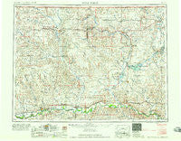
~ Wolf Point MT topo map, 1:250000 scale, 1 X 2 Degree, Historical, 1958
Wolf Point, Montana, USGS topographic map dated 1958.
Includes geographic coordinates (latitude and longitude). This topographic map is suitable for hiking, camping, and exploring, or framing it as a wall map.
Printed on-demand using high resolution imagery, on heavy weight and acid free paper, or alternatively on a variety of synthetic materials.
Topos available on paper, Waterproof, Poly, or Tyvek. Usually shipping rolled, unless combined with other folded maps in one order.
- Product Number: USGS-5402078
- Free digital map download (high-resolution, GeoPDF): Wolf Point, Montana (file size: 20 MB)
- Map Size: please refer to the dimensions of the GeoPDF map above
- Weight (paper map): ca. 55 grams
- Map Type: POD USGS Topographic Map
- Map Series: HTMC
- Map Verison: Historical
- Cell ID: 69107
- Scan ID: 268819
- Woodland Tint: Yes
- Field Check Year: 1954
- Datum: Unstated
- Map Projection: Transverse Mercator
- Map published by United States Geological Survey
- Map Language: English
- Scanner Resolution: 600 dpi
- Map Cell Name: Wolf Point
- Grid size: 1 X 2 Degree
- Date on map: 1958
- Map Scale: 1:250000
- Geographical region: Montana, United States
Neighboring Maps:
All neighboring USGS topo maps are available for sale online at a variety of scales.
Spatial coverage:
Topo map Wolf Point, Montana, covers the geographical area associated the following places:
- Butte Creek - Peerless - Bredette - Outlook - Midby (historical) - Snowden - Whitetail - Slab Crossing - Chelsea - Medicine Lake - Madoc - Leibrands Trailer Court - Scobey - Bakers (historical) - Sprole - Carbert - Calais - Bainville - Finnicum Mobile Home Park - Lakeside - Wanso (historical) - Moes Trailer Court - Kahle (historical) - Lanark - Anderson - Volmer - Rock Crossing - Fort Union (historical) - Biem - Flaxville - Walker Mobile Home Park - Dooley - Pleasant Valley (historical) - Macon - McCabe - Poplar - Deertail Indian Village (historical) - Trails End Trailer Court - Boyd (historical) - Benrud (historical) - Blair - Westby - Vivs Trailer Court - Daleview - Reserve - Redstone - Antelope - West Fork - Comertown - Julian (historical) - Oswego - Archer - Navajo - Arthur (historical) - Homestead - Nickwall - Raymond - Volt - Fort Kipp - Pearmond (historical) - Lustre - Dagmar - Coalridge - Four Buttes - Plentywood - Froid - Culbertson - Brenna Trailer Court - McElroy - Brockton - Wolf Point - Pleasant Prairie
- Map Area ID: AREA4948-106-104
- Northwest corner Lat/Long code: USGSNW49-106
- Northeast corner Lat/Long code: USGSNE49-104
- Southwest corner Lat/Long code: USGSSW48-106
- Southeast corner Lat/Long code: USGSSE48-104
- Northern map edge Latitude: 49
- Southern map edge Latitude: 48
- Western map edge Longitude: -106
- Eastern map edge Longitude: -104


