
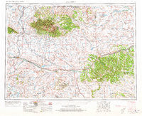
~ Roundup MT topo map, 1:250000 scale, 1 X 2 Degree, Historical, 1954, updated 1973
Roundup, Montana, USGS topographic map dated 1954.
Includes geographic coordinates (latitude and longitude). This topographic map is suitable for hiking, camping, and exploring, or framing it as a wall map.
Printed on-demand using high resolution imagery, on heavy weight and acid free paper, or alternatively on a variety of synthetic materials.
Topos available on paper, Waterproof, Poly, or Tyvek. Usually shipping rolled, unless combined with other folded maps in one order.
- Product Number: USGS-5402054
- Free digital map download (high-resolution, GeoPDF): Roundup, Montana (file size: 18 MB)
- Map Size: please refer to the dimensions of the GeoPDF map above
- Weight (paper map): ca. 55 grams
- Map Type: POD USGS Topographic Map
- Map Series: HTMC
- Map Verison: Historical
- Cell ID: 68995
- Scan ID: 268799
- Imprint Year: 1973
- Woodland Tint: Yes
- Aerial Photo Year: 1953
- Edit Year: 1965
- Field Check Year: 1954
- Datum: Unstated
- Map Projection: Transverse Mercator
- Map published by United States Geological Survey
- Map Language: English
- Scanner Resolution: 600 dpi
- Map Cell Name: Roundup
- Grid size: 1 X 2 Degree
- Date on map: 1954
- Map Scale: 1:250000
- Geographical region: Montana, United States
Neighboring Maps:
All neighboring USGS topo maps are available for sale online at a variety of scales.
Spatial coverage:
Topo map Roundup, Montana, covers the geographical area associated the following places:
- Emory (historical) - Bundy - Shepherds Trailer Court - Heath - McClave - Wheaton (historical) - Philbrook (historical) - Roundup - Sipple - Flatwillow - Hedgesville - Sahara (historical) - Camp Three - Winnecook - Flatwillow Colony - Kilby Butte Colony - Straw - Springwater Colony - Hauck - Musselshell - Eddies Corner - Melville - Gage - Seright (historical) - Harlowton - Cushman - Becket - Belmont - Shawmut - Moore - Golden Valley Colony - Rothiemay - Slayton Junction (historical) - Darrel (historical) - Barber - Warr (historical) - Seventynine (historical) - Shorey (historical) - Dodgetown (historical) - Wallview (historical) - Elso - Norwegian Settlement (historical) - Rockford (historical) - Forestgrove - Broadview - Republic (historical) - Kelley - Judith Gap - Farralltown - Beaver Creek - Gibbtown - Delphia - Buffalo - Klein - Franklin - Lavina - Fattig (historical) - Piper - Battrick (historical) - Riverside - Living Springs - Garneill - Ryegate
- Map Area ID: AREA4746-110-108
- Northwest corner Lat/Long code: USGSNW47-110
- Northeast corner Lat/Long code: USGSNE47-108
- Southwest corner Lat/Long code: USGSSW46-110
- Southeast corner Lat/Long code: USGSSE46-108
- Northern map edge Latitude: 47
- Southern map edge Latitude: 46
- Western map edge Longitude: -110
- Eastern map edge Longitude: -108


