
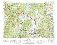
~ Butte MT topo map, 1:250000 scale, 1 X 2 Degree, Historical, 1958
Butte, Montana, USGS topographic map dated 1958.
Includes geographic coordinates (latitude and longitude). This topographic map is suitable for hiking, camping, and exploring, or framing it as a wall map.
Printed on-demand using high resolution imagery, on heavy weight and acid free paper, or alternatively on a variety of synthetic materials.
Topos available on paper, Waterproof, Poly, or Tyvek. Usually shipping rolled, unless combined with other folded maps in one order.
- Product Number: USGS-5401926
- Free digital map download (high-resolution, GeoPDF): Butte, Montana (file size: 27 MB)
- Map Size: please refer to the dimensions of the GeoPDF map above
- Weight (paper map): ca. 55 grams
- Map Type: POD USGS Topographic Map
- Map Series: HTMC
- Map Verison: Historical
- Cell ID: 75030
- Scan ID: 268679
- Woodland Tint: Yes
- Aerial Photo Year: 1976
- Edit Year: 1977
- Field Check Year: 1958
- Datum: Unstated
- Map Projection: Transverse Mercator
- Map published by United States Geological Survey
- Map Language: English
- Scanner Resolution: 600 dpi
- Map Cell Name: Butte
- Grid size: 1 X 2 Degree
- Date on map: 1958
- Map Scale: 1:250000
- Geographical region: Montana, United States
Neighboring Maps:
All neighboring USGS topo maps are available for sale online at a variety of scales.
Spatial coverage:
Topo map Butte, Montana, covers the geographical area associated the following places:
- Racetrack - Stuart - Princeton - Echo Lake (historical) - Nissler - Bradman - Stone - Mill Creek - Burlington (historical) - Hackney - Yreka - Ramsay - Staton - Jens - Basin - Elliston - Frontier Town - McGillvary - Seven Mile (historical) - Opportunity - Clark (historical) - Valley (historical) - North Walkerville (historical) - Kyle - Big Pines Mobile Court - Garrison - Eightmile Saddle - Greenough - Lost Creek - Forest Heights - Turah - Greenland Park Trailer Court - Strom - Springtown - McHugh Trailer Court - Park City - Broadwater - Crackerville - Trask - Fuller - Keiley - Reynolds City - East Butte - Galen - Pioneer - Marysville - Rocker - Emery (historical) - Circle 'J' Mobile Park - McDonald - Amazon - Elk Park - Iron - Tobin - Twin Creeks - Harveys Mobile Home Court - Meaderville - Dutton - Byrne - Tungsten - Goldcreek - Pinegrove - Helena - Top O'Deep - Mine Creek - Columbia Gardens - Anaconda - Finn - Bearmouth - Sunset - Atlantic City (historical) - Helmville - Boulder - Iris - Corral - Piltzville - McNamara - Trinity (historical) - Bonner Junction - Maxville - Ozan - Blue Cloud (historical) - Coloma - Austin - Garnet - Pinegrove Trailer Park - Mountain Valley Trailer Court - Barite - New Chicago - West Valley - Fredrickson (historical) - Ferris (historical) - Kenwood (historical) - Bald Butte - Gregson - Sunnyside - Danielsville - Reynolds Trailer Court - Blackfoot City (historical) - Finlen
- Map Area ID: AREA4746-114-112
- Northwest corner Lat/Long code: USGSNW47-114
- Northeast corner Lat/Long code: USGSNE47-112
- Southwest corner Lat/Long code: USGSSW46-114
- Southeast corner Lat/Long code: USGSSE46-112
- Northern map edge Latitude: 47
- Southern map edge Latitude: 46
- Western map edge Longitude: -114
- Eastern map edge Longitude: -112


