
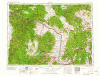
~ Butte MT topo map, 1:250000 scale, 1 X 2 Degree, Historical, 1962
Butte, Montana, USGS topographic map dated 1962.
Includes geographic coordinates (latitude and longitude). This topographic map is suitable for hiking, camping, and exploring, or framing it as a wall map.
Printed on-demand using high resolution imagery, on heavy weight and acid free paper, or alternatively on a variety of synthetic materials.
Topos available on paper, Waterproof, Poly, or Tyvek. Usually shipping rolled, unless combined with other folded maps in one order.
- Product Number: USGS-5401916
- Free digital map download (high-resolution, GeoPDF): Butte, Montana (file size: 26 MB)
- Map Size: please refer to the dimensions of the GeoPDF map above
- Weight (paper map): ca. 55 grams
- Map Type: POD USGS Topographic Map
- Map Series: HTMC
- Map Verison: Historical
- Cell ID: 75030
- Scan ID: 268674
- Woodland Tint: Yes
- Aerial Photo Year: 1958
- Datum: Unstated
- Map Projection: Transverse Mercator
- Map published by United States Geological Survey
- Map Language: English
- Scanner Resolution: 600 dpi
- Map Cell Name: Butte
- Grid size: 1 X 2 Degree
- Date on map: 1962
- Map Scale: 1:250000
- Geographical region: Montana, United States
Neighboring Maps:
All neighboring USGS topo maps are available for sale online at a variety of scales.
Spatial coverage:
Topo map Butte, Montana, covers the geographical area associated the following places:
- Lincoln - Lost Creek - McQueen - Blackfoot City (historical) - Stone - Fuller - Springtown - Morel - Silver Bow Park - Hamblin Heights Mobile Village - Wilborn - Trask - Fairmont Hot Springs - Sunnyside - Gregson - Stump Town - Top O'Deep - Ramsay - Bernice - Yukon Saddle - Hackney - Haskell (historical) - Centerville - New Chicago - Bearmouth - Gird Point - Rieder - Amazon - Park City - Kenwood (historical) - Sharkeyville (historical) - Warm Springs - Birdseye - Dutton - Wickes - Circle 'J' Mobile Park - Canyon Creek - Copper Cliff - Goldcreek - Pioneer - Unionville - McNamara - Kyle - Gold Coin (historical) - Blue Cloud (historical) - Quigley - Galen - Butchertown (historical) - Barite - Eight Mile (historical) - Mount Jumbo Trailer Court - Bradman - Helena - Potomac - Prison Farm - Broadwater - Ferris (historical) - Racetrack - Elk Park - Twin Creeks - Mobile City Home Park - Hall - Yreka - Champion (historical) - Anselmo (historical) - West Valley - Carols Court - Big Foot (historical) - Atlantic City (historical) - Jens - Evergreen Court - Piltzville - McHugh Trailer Court - Butte - Lingenpolter - Baird (historical) - Pinegrove Trailer Park - Nimrod - Danielsville - Missoula - Silver Lake (historical) - Belmont (historical) - Finlen - Porters Corner - Greenough - Mine Creek - North Walkerville (historical) - Allendale (historical) - Pinegrove - Elliston - Corbin - Sunset - Opportunity - Bald Butte - Silver Bow - Glenbeg (historical) - Sherryl - Huckleberry Trailer Court - Anaconda Trailer Court - Columbia Gardens
- Map Area ID: AREA4746-114-112
- Northwest corner Lat/Long code: USGSNW47-114
- Northeast corner Lat/Long code: USGSNE47-112
- Southwest corner Lat/Long code: USGSSW46-114
- Southeast corner Lat/Long code: USGSSE46-112
- Northern map edge Latitude: 47
- Southern map edge Latitude: 46
- Western map edge Longitude: -114
- Eastern map edge Longitude: -112


