
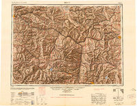
~ Butte MT topo map, 1:250000 scale, 1 X 2 Degree, Historical, 1947, updated 1951
Butte, Montana, USGS topographic map dated 1947.
Includes geographic coordinates (latitude and longitude). This topographic map is suitable for hiking, camping, and exploring, or framing it as a wall map.
Printed on-demand using high resolution imagery, on heavy weight and acid free paper, or alternatively on a variety of synthetic materials.
Topos available on paper, Waterproof, Poly, or Tyvek. Usually shipping rolled, unless combined with other folded maps in one order.
- Product Number: USGS-5401914
- Free digital map download (high-resolution, GeoPDF): Butte, Montana (file size: 20 MB)
- Map Size: please refer to the dimensions of the GeoPDF map above
- Weight (paper map): ca. 55 grams
- Map Type: POD USGS Topographic Map
- Map Series: HTMC
- Map Verison: Historical
- Cell ID: 75030
- Scan ID: 268673
- Imprint Year: 1951
- Aerial Photo Year: 1945
- Datum: NAD27
- Map Projection: Transverse Mercator
- Shaded Relief map: Yes
- Map published by United States Army Corps of Engineers
- Map published by United States Army
- Map Language: English
- Scanner Resolution: 600 dpi
- Map Cell Name: Butte
- Grid size: 1 X 2 Degree
- Date on map: 1947
- Map Scale: 1:250000
- Geographical region: Montana, United States
Neighboring Maps:
All neighboring USGS topo maps are available for sale online at a variety of scales.
Spatial coverage:
Topo map Butte, Montana, covers the geographical area associated the following places:
- Sunnyside - Miller - Sunset Trailer Court - Southern Cross (historical) - Reynolds City - Rimini - Gearing - Nissler - Allendale (historical) - Stump Town - New Chicago - Corral - Greenland Park Trailer Court - Philipsburg - Yukon Saddle - Stuart - Ramsay - Danielsville - Gird Point - Coughlin - Silver Bow Park - Weed - McNamara - Stone - Stump Town (historical) - Park City - Kenwood (historical) - Finlen - Drummond - Big Pines Mobile Court - Garnet - Quigley - Racetrack - McGillvary - Gregson - Butchertown (historical) - Prison Farm - Kyle - Greenough - Silver City - Bonner Junction - Helmville - Champion (historical) - Fairmont Hot Springs - Haskell (historical) - West Valley - Jens - Frontier Town - Clinton - Columbia Gardens - Barite - Dutton - Finn - Strom - Boulder - Crackerville - Keiley - Sharkeyville (historical) - Walkerville - Birdseye - Potomac - Silver Bow - Garrison - Turah - Miles Crossing - East Butte - Quigley - Blackfoot City (historical) - Burnt Fork (historical) - Iron - McDonald - Ravenna - Emery (historical) - Woodville - Seven Mile (historical) - Portal - Blue Cloud (historical) - Bernice - Elk Park - Durant - Basin - Big Foot (historical) - Piltzville - Rocker - West Riverside - Fredrickson (historical) - Mountain Valley Trailer Court - Canyon Creek - Gloster - Iris - Ozan - Elliston - Wall City - Staton - Eight Mile (historical) - East Missoula - Baird (historical) - Pioneer - Reynolds Trailer Court - Comet
- Map Area ID: AREA4746-114-112
- Northwest corner Lat/Long code: USGSNW47-114
- Northeast corner Lat/Long code: USGSNE47-112
- Southwest corner Lat/Long code: USGSSW46-114
- Southeast corner Lat/Long code: USGSSE46-112
- Northern map edge Latitude: 47
- Southern map edge Latitude: 46
- Western map edge Longitude: -114
- Eastern map edge Longitude: -112


