
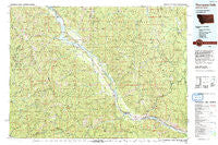
~ Thompson Falls MT topo map, 1:100000 scale, 30 X 60 Minute, Historical, 1992, updated 1993
Thompson Falls, Montana, USGS topographic map dated 1992.
Includes geographic coordinates (latitude and longitude). This topographic map is suitable for hiking, camping, and exploring, or framing it as a wall map.
Printed on-demand using high resolution imagery, on heavy weight and acid free paper, or alternatively on a variety of synthetic materials.
Topos available on paper, Waterproof, Poly, or Tyvek. Usually shipping rolled, unless combined with other folded maps in one order.
- Product Number: USGS-5401620
- Free digital map download (high-resolution, GeoPDF): Thompson Falls, Montana (file size: 40 MB)
- Map Size: please refer to the dimensions of the GeoPDF map above
- Weight (paper map): ca. 55 grams
- Map Type: POD USGS Topographic Map
- Map Series: HTMC
- Map Verison: Historical
- Cell ID: 68456
- Scan ID: 268467
- Imprint Year: 1993
- Woodland Tint: Yes
- Aerial Photo Year: 1983
- Edit Year: 1992
- Datum: NAD27
- Map Projection: Universal Transverse Mercator
- Map published by United States Geological Survey
- Map Language: English
- Scanner Resolution: 600 dpi
- Map Cell Name: Thompson Falls
- Grid size: 30 X 60 Minute
- Date on map: 1992
- Map Scale: 1:100000
- Geographical region: Montana, United States
Neighboring Maps:
All neighboring USGS topo maps are available for sale online at a variety of scales.
Spatial coverage:
Topo map Thompson Falls, Montana, covers the geographical area associated the following places:
- Bunn - Thompson Falls - Gem - Delta - Eagle - Belknap - Carbon Center - Cornwall - Frisco - Shannonville (historical) - Eddy - Ashleys Settlement (historical) - Trout Creek - Ferguson - Larchwood - Thiard - Mace - White Pine - Nuckols - Talc - Sunset (historical) - Noxon - Prichard - Blackcloud - Murray - Snider - Osburn - Childs - Tuscor - Black Bear - Bend - Burke
- Map Area ID: AREA4847.5-116-115
- Northwest corner Lat/Long code: USGSNW48-116
- Northeast corner Lat/Long code: USGSNE48-115
- Southwest corner Lat/Long code: USGSSW47.5-116
- Southeast corner Lat/Long code: USGSSE47.5-115
- Northern map edge Latitude: 48
- Southern map edge Latitude: 47.5
- Western map edge Longitude: -116
- Eastern map edge Longitude: -115


