
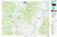
~ Butte South MT topo map, 1:100000 scale, 30 X 60 Minute, Historical, 1975
Butte South, Montana, USGS topographic map dated 1975.
Includes geographic coordinates (latitude and longitude). This topographic map is suitable for hiking, camping, and exploring, or framing it as a wall map.
Printed on-demand using high resolution imagery, on heavy weight and acid free paper, or alternatively on a variety of synthetic materials.
Topos available on paper, Waterproof, Poly, or Tyvek. Usually shipping rolled, unless combined with other folded maps in one order.
- Product Number: USGS-5401500
- Free digital map download (high-resolution, GeoPDF): Butte South, Montana (file size: 31 MB)
- Map Size: please refer to the dimensions of the GeoPDF map above
- Weight (paper map): ca. 55 grams
- Map Type: POD USGS Topographic Map
- Map Series: HTMC
- Map Verison: Historical
- Cell ID: 67207
- Scan ID: 268385
- Woodland Tint: Yes
- Photo Inspection Year: 1990
- Aerial Photo Year: 1974
- Edit Year: 1975
- Datum: NAD27
- Map Projection: Universal Transverse Mercator
- Map published by United States Geological Survey
- Map Language: English
- Scanner Resolution: 600 dpi
- Map Cell Name: Butte South
- Grid size: 30 X 60 Minute
- Date on map: 1975
- Map Scale: 1:100000
- Geographical region: Montana, United States
Neighboring Maps:
All neighboring USGS topo maps are available for sale online at a variety of scales.
Spatial coverage:
Topo map Butte South, Montana, covers the geographical area associated the following places:
- Pappas Place - Mammoth - Johnson - Renova - Whitehall - Moose Town - Cedric - Butte-Silver Bow (balance) - Pipestone Hot Springs - Highland City (historical) - Royston (historical) - Maiden Rock - Nine-mile - Pipestone - Skones - Lion City (historical) - Grace - Divide - Vendome - Donald - Patterson Corner - Tippet Place - French Town - Wise River - La Casa Trailer Park - Red Mountain (historical) - Welch - Melrose - Feely - Homestake - Sunlight - Woodin - Paul Place - Rice Motel and Trailer Court - Williamsburg - Newcomb - Iron Rod (historical) - Piedmont - Waterloo - Floral Park - Sciuchetti Place - Silver Star - Dewey - Leiterville - Delano Place - Buxton - Rochester - Janney - Highview - Glendale - Quinn - Twin Bridges - Valley Vista Mobile Home Community
- Map Area ID: AREA4645.5-113-112
- Northwest corner Lat/Long code: USGSNW46-113
- Northeast corner Lat/Long code: USGSNE46-112
- Southwest corner Lat/Long code: USGSSW45.5-113
- Southeast corner Lat/Long code: USGSSE45.5-112
- Northern map edge Latitude: 46
- Southern map edge Latitude: 45.5
- Western map edge Longitude: -113
- Eastern map edge Longitude: -112


