
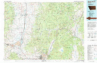
~ Butte North MT topo map, 1:100000 scale, 30 X 60 Minute, Historical, 1994, updated 1994
Butte North, Montana, USGS topographic map dated 1994.
Includes geographic coordinates (latitude and longitude). This topographic map is suitable for hiking, camping, and exploring, or framing it as a wall map.
Printed on-demand using high resolution imagery, on heavy weight and acid free paper, or alternatively on a variety of synthetic materials.
Topos available on paper, Waterproof, Poly, or Tyvek. Usually shipping rolled, unless combined with other folded maps in one order.
- Product Number: USGS-5401498
- Free digital map download (high-resolution, GeoPDF): Butte North, Montana (file size: 30 MB)
- Map Size: please refer to the dimensions of the GeoPDF map above
- Weight (paper map): ca. 55 grams
- Map Type: POD USGS Topographic Map
- Map Series: HTMC
- Map Verison: Historical
- Cell ID: 67206
- Scan ID: 268384
- Imprint Year: 1994
- Woodland Tint: Yes
- Aerial Photo Year: 1991
- Edit Year: 1994
- Datum: NAD27
- Map Projection: Universal Transverse Mercator
- Map published by United States Geological Survey
- Map Language: English
- Scanner Resolution: 600 dpi
- Map Cell Name: Butte North
- Grid size: 30 X 60 Minute
- Date on map: 1994
- Map Scale: 1:100000
- Geographical region: Montana, United States
Neighboring Maps:
All neighboring USGS topo maps are available for sale online at a variety of scales.
Spatial coverage:
Topo map Butte North, Montana, covers the geographical area associated the following places:
- Big Foot (historical) - Allendale (historical) - Stuart - Meaderville - North Walkerville (historical) - Warm Springs - Portal - Mine Creek - Boulder - Woodville - Pioneer - Sunnyside - Bernice - Columbia Gardens - Ramsay - Elk Park - Glenbeg (historical) - Finlen - Kyle - Anselmo (historical) - Sunset Trailer Court - Fairmont Hot Springs - Prison Farm - Anaconda - Anaconda Trailer Court - Hackney - Walkerville - Mountain Valley Trailer Court - Durant - Mill Creek - Hamblin Heights Mobile Village - Basin - Wickes - Leadville - Rieder - AA Westside Mobile Estates - Gregson - Valley (historical) - Racetrack - Butte - Centerville - Deer Lodge - Hunters Trailer Court - Morel - Silver Bow Park - Stringtown (historical) - Rocker - Miles Crossing - Lost Creek - Comet - Fuller - East Butte - Galen - Opportunity - Crackerville - Corbin - Staton - Silver Bow - Champion (historical) - Butchertown (historical) - Fredrickson (historical) - Rimini - Nissler - Emery (historical) - Burlington (historical) - Trask - McQueen - Jefferson City - Amazon
- Map Area ID: AREA46.546-113-112
- Northwest corner Lat/Long code: USGSNW46.5-113
- Northeast corner Lat/Long code: USGSNE46.5-112
- Southwest corner Lat/Long code: USGSSW46-113
- Southeast corner Lat/Long code: USGSSE46-112
- Northern map edge Latitude: 46.5
- Southern map edge Latitude: 46
- Western map edge Longitude: -113
- Eastern map edge Longitude: -112


