
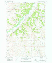
~ Whitebird School MT topo map, 1:24000 scale, 7.5 X 7.5 Minute, Historical, 1955, updated 1978
Whitebird School, Montana, USGS topographic map dated 1955.
Includes geographic coordinates (latitude and longitude). This topographic map is suitable for hiking, camping, and exploring, or framing it as a wall map.
Printed on-demand using high resolution imagery, on heavy weight and acid free paper, or alternatively on a variety of synthetic materials.
Topos available on paper, Waterproof, Poly, or Tyvek. Usually shipping rolled, unless combined with other folded maps in one order.
- Product Number: USGS-5400258
- Free digital map download (high-resolution, GeoPDF): Whitebird School, Montana (file size: 11 MB)
- Map Size: please refer to the dimensions of the GeoPDF map above
- Weight (paper map): ca. 55 grams
- Map Type: POD USGS Topographic Map
- Map Series: HTMC
- Map Verison: Historical
- Cell ID: 48792
- Scan ID: 267565
- Imprint Year: 1978
- Woodland Tint: Yes
- Aerial Photo Year: 1955
- Datum: NAD27
- Map Projection: Polyconic
- Map published by United States Geological Survey
- Map Language: English
- Scanner Resolution: 600 dpi
- Map Cell Name: Whitebird School
- Grid size: 7.5 X 7.5 Minute
- Date on map: 1955
- Map Scale: 1:24000
- Geographical region: Montana, United States
Neighboring Maps:
All neighboring USGS topo maps are available for sale online at a variety of scales.
Spatial coverage:
Topo map Whitebird School, Montana, covers the geographical area associated the following places:
- Swinging Bridge Fishing Access Site - 03S19E13CCAA01 Well - 03S20E05BAAB01 Well - Shane Creek - Columbus Division - 03S20E05ABBB01 Well - Whitebird Fishing Access Site - Firemans Point - 03S19E13CCAD01 Well - 03S19E13CCAA02 Well - Porter Coulee - 02S20E32ADDC01 Well - 04S19E03BCDA01 Well - Orson Coulee - 03S20E07AADB01 Well - Mexican Joe Creek - 03S19E23BABD01 Well - Shane Ditch - Scott Ditch - 03S19E13CACB01 Well - Joe Hill Creek - Norve Coulee - 03S19E13CCAB01 Well - Whitebird Creek - Firemans Point Fishing Access Site - 03S20E05BAAA01 Well - 02S20E32ABAA01 Well - Whitebird Ditch - 03S20E05ABBB02 Well - 03S19E23ABCD01 Well - Halfway House (historical) - Whitebird School (historical) - 03S19E13CBAC01 Well - 02S20E32DDBB01 Well
- Map Area ID: AREA45.62545.5-109.375-109.25
- Northwest corner Lat/Long code: USGSNW45.625-109.375
- Northeast corner Lat/Long code: USGSNE45.625-109.25
- Southwest corner Lat/Long code: USGSSW45.5-109.375
- Southeast corner Lat/Long code: USGSSE45.5-109.25
- Northern map edge Latitude: 45.625
- Southern map edge Latitude: 45.5
- Western map edge Longitude: -109.375
- Eastern map edge Longitude: -109.25


