
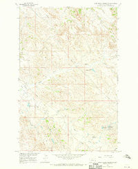
~ Upper Magpie Reservoir MT topo map, 1:24000 scale, 7.5 X 7.5 Minute, Historical, 1967, updated 1970
Upper Magpie Reservoir, Montana, USGS topographic map dated 1967.
Includes geographic coordinates (latitude and longitude). This topographic map is suitable for hiking, camping, and exploring, or framing it as a wall map.
Printed on-demand using high resolution imagery, on heavy weight and acid free paper, or alternatively on a variety of synthetic materials.
Topos available on paper, Waterproof, Poly, or Tyvek. Usually shipping rolled, unless combined with other folded maps in one order.
- Product Number: USGS-5399884
- Free digital map download (high-resolution, GeoPDF): Upper Magpie Reservoir, Montana (file size: 13 MB)
- Map Size: please refer to the dimensions of the GeoPDF map above
- Weight (paper map): ca. 55 grams
- Map Type: POD USGS Topographic Map
- Map Series: HTMC
- Map Verison: Historical
- Cell ID: 46414
- Scan ID: 267346
- Imprint Year: 1970
- Woodland Tint: Yes
- Aerial Photo Year: 1965
- Field Check Year: 1967
- Datum: NAD27
- Map Projection: Polyconic
- Map published by United States Geological Survey
- Map Language: English
- Scanner Resolution: 600 dpi
- Map Cell Name: Upper Magpie Reservoir
- Grid size: 7.5 X 7.5 Minute
- Date on map: 1967
- Map Scale: 1:24000
- Geographical region: Montana, United States
Neighboring Maps:
All neighboring USGS topo maps are available for sale online at a variety of scales.
Spatial coverage:
Topo map Upper Magpie Reservoir, Montana, covers the geographical area associated the following places:
- Dead Horse Dam - Juniper Dam - Gas City Oil Field - Upper Magpie Reservoir - 14N55E27CDDB01 Well - 14N55E27CD__01 Well - Camp Reservoir - 14N56E09ADDB01 Well - Abbot Draw - 14N56E21ABAD01 Well - Gertison Dam - Basin View Dam - Bailer Reservoir - Forks Reservoir - Upper Magpie Reservoir Dam - Prairie Goat Dam - Prairie Goat Reservoir - North Pine Oil Field - Upper Prairie Goat Dam - Bailer Reservoir Dam - Twin Buttes Retention Dam - Ceder Bell Number 2 Dam - Gertison Dam - 13N56E30CCBC01 Well - Big Drop Reservoir - Magpie Creek
- Map Area ID: AREA4746.875-104.75-104.625
- Northwest corner Lat/Long code: USGSNW47-104.75
- Northeast corner Lat/Long code: USGSNE47-104.625
- Southwest corner Lat/Long code: USGSSW46.875-104.75
- Southeast corner Lat/Long code: USGSSE46.875-104.625
- Northern map edge Latitude: 47
- Southern map edge Latitude: 46.875
- Western map edge Longitude: -104.75
- Eastern map edge Longitude: -104.625


