
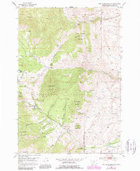
~ Twin Adams Mountain MT topo map, 1:24000 scale, 7.5 X 7.5 Minute, Historical, 1952, updated 1989
Twin Adams Mountain, Montana, USGS topographic map dated 1952.
Includes geographic coordinates (latitude and longitude). This topographic map is suitable for hiking, camping, and exploring, or framing it as a wall map.
Printed on-demand using high resolution imagery, on heavy weight and acid free paper, or alternatively on a variety of synthetic materials.
Topos available on paper, Waterproof, Poly, or Tyvek. Usually shipping rolled, unless combined with other folded maps in one order.
- Product Number: USGS-5399810
- Free digital map download (high-resolution, GeoPDF): Twin Adams Mountain, Montana (file size: 14 MB)
- Map Size: please refer to the dimensions of the GeoPDF map above
- Weight (paper map): ca. 55 grams
- Map Type: POD USGS Topographic Map
- Map Series: HTMC
- Map Verison: Historical
- Cell ID: 46082
- Scan ID: 267306
- Imprint Year: 1989
- Woodland Tint: Yes
- Photo Revision Year: 1988
- Aerial Photo Year: 1984
- Edit Year: 1988
- Field Check Year: 1952
- Datum: NAD27
- Map Projection: Polyconic
- Map published by United States Geological Survey
- Map Language: English
- Scanner Resolution: 600 dpi
- Map Cell Name: Twin Adams Mountain
- Grid size: 7.5 X 7.5 Minute
- Date on map: 1952
- Map Scale: 1:24000
- Geographical region: Montana, United States
Neighboring Maps:
All neighboring USGS topo maps are available for sale online at a variety of scales.
Spatial coverage:
Topo map Twin Adams Mountain, Montana, covers the geographical area associated the following places:
- Birch Creek Ranger Station - Indian Queen Mine - Twin Adams Mine - DuBois Creek - Sheep Creek - Greenstone Mountain - North Creek - Bridge Gulch - SE SW Section 16 Mine - Spring Gulch - Canyon Gulch - Armstrong Mountain - Aspen Campground - Cow Camp - Sugar Loaf Mine - Armstrong Gulch - Bond Lake Dam - Barbour Gulch Mine - Limestone Mountain - Lime Gulch Mine - Lost Fraction Mine - Farlin Post Office (historical) - Glowworm/Greenhorn Mine - Barbour Gulch - Greenstone Mine - Middle Mountain - Upper Bridge Gulch Mine - Farlin Gulch - Meyers Gulch - 05S10W02DABB01 Spring - Lower Bridge Gulch Mine - Twin Adams Mountain - Bond Creek - Farlin (historical) - Thief Creek - Farlin School (historical) - Lime Gulch - Thunderhead Mountain - Call Mountain
- Map Area ID: AREA45.545.375-112.875-112.75
- Northwest corner Lat/Long code: USGSNW45.5-112.875
- Northeast corner Lat/Long code: USGSNE45.5-112.75
- Southwest corner Lat/Long code: USGSSW45.375-112.875
- Southeast corner Lat/Long code: USGSSE45.375-112.75
- Northern map edge Latitude: 45.5
- Southern map edge Latitude: 45.375
- Western map edge Longitude: -112.875
- Eastern map edge Longitude: -112.75


