
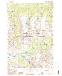
~ Tumble Mountain MT topo map, 1:24000 scale, 7.5 X 7.5 Minute, Historical, 1986, updated 1986
Tumble Mountain, Montana, USGS topographic map dated 1986.
Includes geographic coordinates (latitude and longitude). This topographic map is suitable for hiking, camping, and exploring, or framing it as a wall map.
Printed on-demand using high resolution imagery, on heavy weight and acid free paper, or alternatively on a variety of synthetic materials.
Topos available on paper, Waterproof, Poly, or Tyvek. Usually shipping rolled, unless combined with other folded maps in one order.
- Product Number: USGS-5399790
- Free digital map download (high-resolution, GeoPDF): Tumble Mountain, Montana (file size: 16 MB)
- Map Size: please refer to the dimensions of the GeoPDF map above
- Weight (paper map): ca. 55 grams
- Map Type: POD USGS Topographic Map
- Map Series: HTMC
- Map Verison: Historical
- Cell ID: 45907
- Scan ID: 267293
- Imprint Year: 1986
- Woodland Tint: Yes
- Aerial Photo Year: 1981
- Edit Year: 1986
- Field Check Year: 1983
- Datum: NAD27
- Map Projection: Lambert Conformal Conic
- Provisional map: Yes
- Map published by United States Geological Survey
- Map Language: English
- Scanner Resolution: 600 dpi
- Map Cell Name: Tumble Mountain
- Grid size: 7.5 X 7.5 Minute
- Date on map: 1986
- Map Scale: 1:24000
- Geographical region: Montana, United States
Neighboring Maps:
All neighboring USGS topo maps are available for sale online at a variety of scales.
Spatial coverage:
Topo map Tumble Mountain, Montana, covers the geographical area associated the following places:
- Asteroid Lake - Fish Lake - Tumble Mountain - Lightning Lake - Needle Lake - Chalice Peak - Lake Pisce - Saderbalm Lake - Rabbit Gulch - Dryad Lake - Wounded Man Lake - Comet Lake - Chalice Lake - Dreary Lake - Lake Plateau - Lake Pinchot - Lake Diaphanous - Crescent Creek - Divide Creek - Lake Surrender - Two Sisters - Barrier Lake - Trouble Lake - Cimmerian Lake - Hermit Lake - Bill Lake - Pipit Lake - Lake Vengence - Jay Lake - Ravin Lake - Hidden Creek - Lewis Creek - Owl Lake - Lightning Creek - Trail Creek - Lake Mountain - Tumble Creek - Clam Lake - Jasper Lake
- Map Area ID: AREA45.37545.25-110.125-110
- Northwest corner Lat/Long code: USGSNW45.375-110.125
- Northeast corner Lat/Long code: USGSNE45.375-110
- Southwest corner Lat/Long code: USGSSW45.25-110.125
- Southeast corner Lat/Long code: USGSSE45.25-110
- Northern map edge Latitude: 45.375
- Southern map edge Latitude: 45.25
- Western map edge Longitude: -110.125
- Eastern map edge Longitude: -110


