
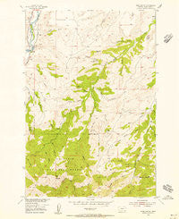
~ Ross Canyon MT topo map, 1:24000 scale, 7.5 X 7.5 Minute, Historical, 1954, updated 1956
Ross Canyon, Montana, USGS topographic map dated 1954.
Includes geographic coordinates (latitude and longitude). This topographic map is suitable for hiking, camping, and exploring, or framing it as a wall map.
Printed on-demand using high resolution imagery, on heavy weight and acid free paper, or alternatively on a variety of synthetic materials.
Topos available on paper, Waterproof, Poly, or Tyvek. Usually shipping rolled, unless combined with other folded maps in one order.
- Product Number: USGS-5398266
- Free digital map download (high-resolution, GeoPDF): Ross Canyon, Montana (file size: 12 MB)
- Map Size: please refer to the dimensions of the GeoPDF map above
- Weight (paper map): ca. 55 grams
- Map Type: POD USGS Topographic Map
- Map Series: HTMC
- Map Verison: Historical
- Cell ID: 38661
- Scan ID: 266421
- Imprint Year: 1956
- Woodland Tint: Yes
- Aerial Photo Year: 1951
- Field Check Year: 1954
- Datum: NAD27
- Map Projection: Polyconic
- Map published by United States Geological Survey
- Map Language: English
- Scanner Resolution: 600 dpi
- Map Cell Name: Ross Canyon
- Grid size: 7.5 X 7.5 Minute
- Date on map: 1954
- Map Scale: 1:24000
- Geographical region: Montana, United States
Neighboring Maps:
All neighboring USGS topo maps are available for sale online at a variety of scales.
Spatial coverage:
Topo map Ross Canyon, Montana, covers the geographical area associated the following places:
- Asp Gulch - Chimney Rock Creek - Davis Creek - Sawmill Gulch - Tomato Can Gulch - 01S14E21ACAD01 Well - Eightmile Bridge - Nicely Gulch - Lambing Gulch - Breck Gulch - 01S14E21AABB01 Well - Black Butte - Wood Gulch - Red Mountain - Clause Creek - Spotts Gulch - Cartwright Gulch - Baker Canyon - Piano Hill - Lee Gulch - Calcie Gulch - Ross Spring - Log Cabin Creek - Ross Canyon - Slide Rock Gulch - Harris Gulch - 01S14E21AADD01 Well - Needle Creek - Box Canyon - Dead Horse Gulch - Crest Ditch - Cedar Creek - Rudd Canyon - West Fork Upper Deer Creek - 01S14E28AAAD01 Well - Decker Gulch - Trail Gulch - Whistle Creek - Bear Gulch - McKenzie Flats
- Map Area ID: AREA45.7545.625-110-109.875
- Northwest corner Lat/Long code: USGSNW45.75-110
- Northeast corner Lat/Long code: USGSNE45.75-109.875
- Southwest corner Lat/Long code: USGSSW45.625-110
- Southeast corner Lat/Long code: USGSSE45.625-109.875
- Northern map edge Latitude: 45.75
- Southern map edge Latitude: 45.625
- Western map edge Longitude: -110
- Eastern map edge Longitude: -109.875


