
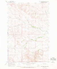
~ Little Sheep Mountain MT topo map, 1:24000 scale, 7.5 X 7.5 Minute, Historical, 1965, updated 1968
Little Sheep Mountain, Montana, USGS topographic map dated 1965.
Includes geographic coordinates (latitude and longitude). This topographic map is suitable for hiking, camping, and exploring, or framing it as a wall map.
Printed on-demand using high resolution imagery, on heavy weight and acid free paper, or alternatively on a variety of synthetic materials.
Topos available on paper, Waterproof, Poly, or Tyvek. Usually shipping rolled, unless combined with other folded maps in one order.
- Product Number: USGS-5395904
- Free digital map download (high-resolution, GeoPDF): Little Sheep Mountain, Montana (file size: 10 MB)
- Map Size: please refer to the dimensions of the GeoPDF map above
- Weight (paper map): ca. 55 grams
- Map Type: POD USGS Topographic Map
- Map Series: HTMC
- Map Verison: Historical
- Cell ID: 26043
- Scan ID: 265044
- Imprint Year: 1968
- Woodland Tint: Yes
- Aerial Photo Year: 1964
- Field Check Year: 1965
- Datum: NAD27
- Map Projection: Polyconic
- Map published by United States Geological Survey
- Map Language: English
- Scanner Resolution: 600 dpi
- Map Cell Name: Little Sheep Mountain
- Grid size: 7.5 X 7.5 Minute
- Date on map: 1965
- Map Scale: 1:24000
- Geographical region: Montana, United States
Neighboring Maps:
All neighboring USGS topo maps are available for sale online at a variety of scales.
Spatial coverage:
Topo map Little Sheep Mountain, Montana, covers the geographical area associated the following places:
- 14N47E08BDDC01 Well - Devlin Ranch - 14N47E32CCBC01 Well - 14N47E08BDDB01 Well - 13N47E03CABB01 Well - 14N47E20DCCB01 Well - Pershing School (historical) - McDevlin Number 2 Dam - 14N47E17AADB01 Well - 14N47E05CCBA01 Well - South Fork School (historical) - 14N46E13DBDC01 Well - 13N47E06ACBA01 Well - De Grand Post Office (historical) - 13N47E15CABC01 Well - 14N46E13DDDC01 Well - 13N46E02DDCC01 Well - 13N46E12DCDD01 Well - 14N47E20CBDB01 Well - 14N47E20DCCA01 Well - 13N47E07ABBD01 Well - 14N47E04ADCC01 Well - 14N46E36BCAB01 Well - Barney Creek - Little Sheep Mountain - 14N47E19CBBD01 Well - Keltner Number 1 Dam - 13N47E03CCDD01 Well
- Map Area ID: AREA4746.875-105.875-105.75
- Northwest corner Lat/Long code: USGSNW47-105.875
- Northeast corner Lat/Long code: USGSNE47-105.75
- Southwest corner Lat/Long code: USGSSW46.875-105.875
- Southeast corner Lat/Long code: USGSSE46.875-105.75
- Northern map edge Latitude: 47
- Southern map edge Latitude: 46.875
- Western map edge Longitude: -105.875
- Eastern map edge Longitude: -105.75


