
~ Hot Springs NE MT topo map, 1:24000 scale, 7.5 X 7.5 Minute, Historical, 1964, updated 1967
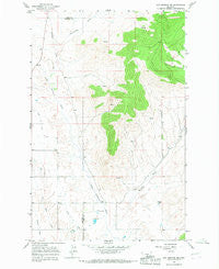
Hot Springs NE, Montana, USGS topographic map dated 1964.
Includes geographic coordinates (latitude and longitude). This topographic map is suitable for hiking, camping, and exploring, or framing it as a wall map.
Printed on-demand using high resolution imagery, on heavy weight and acid free paper, or alternatively on a variety of synthetic materials.
Topos available on paper, Waterproof, Poly, or Tyvek. Usually shipping rolled, unless combined with other folded maps in one order.
- Product Number: USGS-5395020
- Free digital map download (high-resolution, GeoPDF): Hot Springs NE, Montana (file size: 10 MB)
- Map Size: please refer to the dimensions of the GeoPDF map above
- Weight (paper map): ca. 55 grams
- Map Type: POD USGS Topographic Map
- Map Series: HTMC
- Map Verison: Historical
- Cell ID: 21191
- Scan ID: 264527
- Imprint Year: 1967
- Woodland Tint: Yes
- Aerial Photo Year: 1963
- Field Check Year: 1964
- Datum: NAD27
- Map Projection: Polyconic
- Map published by United States Geological Survey
- Map Language: English
- Scanner Resolution: 600 dpi
- Map Cell Name: Hot Springs NE
- Grid size: 7.5 X 7.5 Minute
- Date on map: 1964
- Map Scale: 1:24000
- Geographical region: Montana, United States
Neighboring Maps:
All neighboring USGS topo maps are available for sale online at a variety of scales.
Spatial coverage:
Topo map Hot Springs NE, Montana, covers the geographical area associated the following places:
- 22N23W20DCD_01 Well - 22N23W17CBB_01 Well - 22N23W28CBD_01 Well - 22N23W28CAC_01 Well - 22N24W24ABBD01 Well - 22N23W30DBCD01 Well - 22N24W01BDCC01 Well - 22N23W29ACAB01 Well - 22N23W20CDBC01 Well - 22N23W17BBC_01 Well - 22N23W29AAD_01 Well - 22N24W13BCB_01 Well - 22N23W20BAAD01 Well - 22N23W07BBD_01 Well - 22N23W15CDDD01 Well - 22N23W29CACA01 Well - 22N23W07DBD_01 Well - 22N23W18ACA_01 Well - Garcon Gulch - Marine Dam - Aqua Dam - 22N23W17BBDD01 Well - 22N23W20DDC_01 Well - 22N23W33BDA_01 Well - 22N24W24ADA_01 Well - 22N23W18DDA_01 Well - 22N24W12ACCC01 Well - 22N23W29BADD01 Well - 22N23W17CDB_01 Well - 22N23W33BAB_01 Well - 22N23W20BCCB01 Well - Camas B Canal - 22N23W19DAA_01 Well - 22N23W19CBD_01 Well - 22N23W29CCCC01 Well - 22N23W17BCB_01 Well - 23N24W35BAA_02 Well - 22N24W01CBD_01 Well - 22N23W28BADD01 Well - 22N23W15DCDC01 Well - 22N23W29BAA_01 Well - 23N24W24CAC_01 Well - 23N24W25DAD_01 Well - 22N24W13DAD_01 Well - Sullivan Creek - Wildhorse Hot Springs - 22N23W07BBD_02 Well - Rattlesnake Gulch - 22N23W28CBB_01 Well - 22N24W36BBB_01 Well - 22N23W18BBB_01 Well - 22N23W29ACB_01 Well - 23N24W36CAA_01 Well - 22N23W19______ Well - 22N23W34AAA_01 Well - 22N23W32BCB_01 Well
- Map Area ID: AREA47.7547.625-114.625-114.5
- Northwest corner Lat/Long code: USGSNW47.75-114.625
- Northeast corner Lat/Long code: USGSNE47.75-114.5
- Southwest corner Lat/Long code: USGSSW47.625-114.625
- Southeast corner Lat/Long code: USGSSE47.625-114.5
- Northern map edge Latitude: 47.75
- Southern map edge Latitude: 47.625
- Western map edge Longitude: -114.625
- Eastern map edge Longitude: -114.5


