
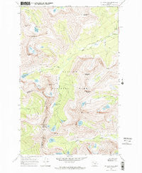
~ Cut Bank Pass MT topo map, 1:24000 scale, 7.5 X 7.5 Minute, Historical, 1968, updated 1971
Cut Bank Pass, Montana, USGS topographic map dated 1968.
Includes geographic coordinates (latitude and longitude). This topographic map is suitable for hiking, camping, and exploring, or framing it as a wall map.
Printed on-demand using high resolution imagery, on heavy weight and acid free paper, or alternatively on a variety of synthetic materials.
Topos available on paper, Waterproof, Poly, or Tyvek. Usually shipping rolled, unless combined with other folded maps in one order.
- Product Number: USGS-5392834
- Free digital map download (high-resolution, GeoPDF): Cut Bank Pass, Montana (file size: 13 MB)
- Map Size: please refer to the dimensions of the GeoPDF map above
- Weight (paper map): ca. 55 grams
- Map Type: POD USGS Topographic Map
- Map Series: HTMC
- Map Verison: Historical
- Cell ID: 69806
- Scan ID: 263267
- Imprint Year: 1971
- Woodland Tint: Yes
- Visual Version Number: 1
- Aerial Photo Year: 1966
- Field Check Year: 1968
- Datum: NAD27
- Map Projection: Polyconic
- Map published by United States Geological Survey
- Map Language: English
- Scanner Resolution: 600 dpi
- Map Cell Name: Cut Bank Pass
- Grid size: 7.5 X 7.5 Minute
- Date on map: 1968
- Map Scale: 1:24000
- Geographical region: Montana, United States
Neighboring Maps:
All neighboring USGS topo maps are available for sale online at a variety of scales.
Spatial coverage:
Topo map Cut Bank Pass, Montana, covers the geographical area associated the following places:
- Mount Morgan - Medicine Grizzly Lake - Boy Lake - Morning Star Lake - Cut Bank Ranger Station - Atlantic Falls - Red Mountain - Sky Lake - McClintock Peak - Running Crane Lake - Pitamakan Lake - Oldman Lake - Bad Marriage Mountain - Young Man Lake - Medicine Owl Peak - Katoya Lake - Lonely Lakes - Medicine Grizzly Trail - Kupunkamint Mountain - Cut Bank Pass Trail - Medicine Owl Lake - Seven Winds of the Lake - Amphitheater Mountain - Cut Bank Campground - Cut Bank Pass - Mount James - Pitamakan Pass Trail - Eagle Plume Mountain - Atlantic Creek - Pitamakan Pass - Medicine Grizzly Peak
- Map Area ID: AREA48.62548.5-113.5-113.375
- Northwest corner Lat/Long code: USGSNW48.625-113.5
- Northeast corner Lat/Long code: USGSNE48.625-113.375
- Southwest corner Lat/Long code: USGSSW48.5-113.5
- Southeast corner Lat/Long code: USGSSE48.5-113.375
- Northern map edge Latitude: 48.625
- Southern map edge Latitude: 48.5
- Western map edge Longitude: -113.5
- Eastern map edge Longitude: -113.375


