
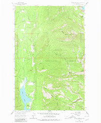
~ Crowell Mountain MT topo map, 1:24000 scale, 7.5 X 7.5 Minute, Historical, 1963, updated 1980
Crowell Mountain, Montana, USGS topographic map dated 1963.
Includes geographic coordinates (latitude and longitude). This topographic map is suitable for hiking, camping, and exploring, or framing it as a wall map.
Printed on-demand using high resolution imagery, on heavy weight and acid free paper, or alternatively on a variety of synthetic materials.
Topos available on paper, Waterproof, Poly, or Tyvek. Usually shipping rolled, unless combined with other folded maps in one order.
- Product Number: USGS-5392806
- Free digital map download (high-resolution, GeoPDF): Crowell Mountain, Montana (file size: 13 MB)
- Map Size: please refer to the dimensions of the GeoPDF map above
- Weight (paper map): ca. 55 grams
- Map Type: POD USGS Topographic Map
- Map Series: HTMC
- Map Verison: Historical
- Cell ID: 10873
- Scan ID: 263246
- Imprint Year: 1980
- Woodland Tint: Yes
- Aerial Photo Year: 1962
- Field Check Year: 1963
- Datum: NAD27
- Map Projection: Polyconic
- Map published by United States Geological Survey
- Map Language: English
- Scanner Resolution: 600 dpi
- Map Cell Name: Crowell Mountain
- Grid size: 7.5 X 7.5 Minute
- Date on map: 1963
- Map Scale: 1:24000
- Geographical region: Montana, United States
Neighboring Maps:
All neighboring USGS topo maps are available for sale online at a variety of scales.
Spatial coverage:
Topo map Crowell Mountain, Montana, covers the geographical area associated the following places:
- Keeler Creek - Pine Ridge - 29N33W20CCDA01 Well - Bull Lake Volunteer Fire Department - Crowell Mountain - 30N33W32ACAD01 Well - Upper Cedar Lake - 30N33W30DCAD02 Well - Madge Creek - 30N33W20BBAB01 Well - 30N33W31AAAC01 Well - 30N33W17BCCB01 Well - 30N33W32ADCB01 Well - 29N33W08BDAC01 Well - Stanley Creek - 30N33W30DAAD01 Well - Emma Gulch - 30N33W31DCBD01 Well - 29N33W29ACBA01 Well - Crowell Creek - 29N33W17ACAA01 Well - 30N33W18AACC01 Well - 30N33W32ACDB01 Well - Porcupine Creek - Callows Island - Dome Mountain - 30N33W18ACDB01 Well - 30N33W29DABC01 Well - Halfway House - Copper Creek - Little Joe - 29N33W17ABAA01 Well - Dorr Skeels Campground - Twin Creek - 30N33W20BBBC01 Well - 30N33W20DCCA01 Well - 30N33W30DAAD02 Well - 30N33W32ABDB01 Well - 30N33W29ACDC01 Well - 30N33W19ACCC01 Well - Camp Creek - 30N33W18ACDD01 Well - Dry Creek - 30N33W29DCAC01 Well - Gordon Mountain - 30N33W32ACBD01 Well - 29N33W20CCDC01 Well - 30N33W32ADCA01 Well - Spring Creek - 29N33W17AACC01 Well - 29N33W20CDBD01 Well - Pheasant Point - 30N33W20ADDC01 Well - Crowell Trail - Hidden Creek - 30N33W30DCAD01 Well - 29N33W17AABB01 Well - Doonan Peak - 30N33W20AADB01 Well - 29N33W17ACAA02 Well
- Map Area ID: AREA48.37548.25-115.875-115.75
- Northwest corner Lat/Long code: USGSNW48.375-115.875
- Northeast corner Lat/Long code: USGSNE48.375-115.75
- Southwest corner Lat/Long code: USGSSW48.25-115.875
- Southeast corner Lat/Long code: USGSSE48.25-115.75
- Northern map edge Latitude: 48.375
- Southern map edge Latitude: 48.25
- Western map edge Longitude: -115.875
- Eastern map edge Longitude: -115.75


