
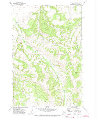
~ Castle Butte MT topo map, 1:24000 scale, 7.5 X 7.5 Minute, Historical, 1970, updated 1973
Castle Butte, Montana, USGS topographic map dated 1970.
Includes geographic coordinates (latitude and longitude). This topographic map is suitable for hiking, camping, and exploring, or framing it as a wall map.
Printed on-demand using high resolution imagery, on heavy weight and acid free paper, or alternatively on a variety of synthetic materials.
Topos available on paper, Waterproof, Poly, or Tyvek. Usually shipping rolled, unless combined with other folded maps in one order.
- Product Number: USGS-5392196
- Free digital map download (high-resolution, GeoPDF): Castle Butte, Montana (file size: 12 MB)
- Map Size: please refer to the dimensions of the GeoPDF map above
- Weight (paper map): ca. 55 grams
- Map Type: POD USGS Topographic Map
- Map Series: HTMC
- Map Verison: Historical
- Cell ID: 7570
- Scan ID: 262885
- Imprint Year: 1973
- Woodland Tint: Yes
- Aerial Photo Year: 1968
- Field Check Year: 1970
- Datum: NAD27
- Map Projection: Lambert Conformal Conic
- Map published by United States Geological Survey
- Map Language: English
- Scanner Resolution: 600 dpi
- Map Cell Name: Castle Butte
- Grid size: 7.5 X 7.5 Minute
- Date on map: 1970
- Map Scale: 1:24000
- Geographical region: Montana, United States
Neighboring Maps:
All neighboring USGS topo maps are available for sale online at a variety of scales.
Spatial coverage:
Topo map Castle Butte, Montana, covers the geographical area associated the following places:
- Castle Hill Ski Area - Casino Creek School (historical) - Mill Creek - Lewistown Division - 14N18E09DDC_01 Well - Natal Post Office (historical) - Quickenden School (historical) - 14N18E17BCA_01 Well - 14N18E18BDB_01 Well - Lyon Canyon - Beaver Creek - Cottonwood Rural Fire District - Camp Lewtana - Hay Canyon - 14N18E15DDBB01 Well - 14N18E16AADD01 Well - Castle Butte - 14N18E04DCBB02 Well - Castle Butte School (historical) - Jones Post Office (historical) - Upper Paradise School (historical) - 14N18E09ADA_01 Well - 14N18E04DCBB01 Well - Cottonwood School - Watson (historical) - 14N18E10DDB_01 Well - Upper Cottonwood School (historical) - Natal School (historical) - 14N18E11ACBA01 Well - 14N18E12CCD_01 Well - 14N18E16CDB_01 Well
- Map Area ID: AREA4746.875-109.5-109.375
- Northwest corner Lat/Long code: USGSNW47-109.5
- Northeast corner Lat/Long code: USGSNE47-109.375
- Southwest corner Lat/Long code: USGSSW46.875-109.5
- Southeast corner Lat/Long code: USGSSE46.875-109.375
- Northern map edge Latitude: 47
- Southern map edge Latitude: 46.875
- Western map edge Longitude: -109.5
- Eastern map edge Longitude: -109.375


