
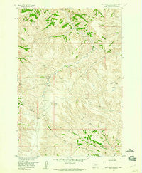
~ Bull Creek Lookout MT topo map, 1:24000 scale, 7.5 X 7.5 Minute, Historical, 1958, updated 1960
Bull Creek Lookout, Montana, USGS topographic map dated 1958.
Includes geographic coordinates (latitude and longitude). This topographic map is suitable for hiking, camping, and exploring, or framing it as a wall map.
Printed on-demand using high resolution imagery, on heavy weight and acid free paper, or alternatively on a variety of synthetic materials.
Topos available on paper, Waterproof, Poly, or Tyvek. Usually shipping rolled, unless combined with other folded maps in one order.
- Product Number: USGS-5391890
- Free digital map download (high-resolution, GeoPDF): Bull Creek Lookout, Montana (file size: 13 MB)
- Map Size: please refer to the dimensions of the GeoPDF map above
- Weight (paper map): ca. 55 grams
- Map Type: POD USGS Topographic Map
- Map Series: HTMC
- Map Verison: Historical
- Cell ID: 6120
- Scan ID: 262721
- Imprint Year: 1960
- Woodland Tint: Yes
- Aerial Photo Year: 1956
- Field Check Year: 1958
- Datum: NAD27
- Map Projection: Polyconic
- Map published by United States Geological Survey
- Map Language: English
- Scanner Resolution: 600 dpi
- Map Cell Name: Bull Creek Lookout
- Grid size: 7.5 X 7.5 Minute
- Date on map: 1958
- Map Scale: 1:24000
- Geographical region: Montana, United States
Neighboring Maps:
All neighboring USGS topo maps are available for sale online at a variety of scales.
Spatial coverage:
Topo map Bull Creek Lookout, Montana, covers the geographical area associated the following places:
- Bull Creek Lookout - 05S40E18BCCA01 Spring - Wild Hog Basin - Brown Camp - Hardrobe Water Gap - North Fork Bull Creek - Big Bend - Middle Fork Bull Creek - Muddy Lake - Hardrobe Spring - 01N43E08ACCD01 Well - Brady Creek - 05S40E09AADD01 Spring - Hardrobe Creek - 05S40E05CCCC01 Spring - Killsnight Spring - 05S40E06ABAB01 Spring - 04S40E17ABD_01 Well
- Map Area ID: AREA45.545.375-106.875-106.75
- Northwest corner Lat/Long code: USGSNW45.5-106.875
- Northeast corner Lat/Long code: USGSNE45.5-106.75
- Southwest corner Lat/Long code: USGSSW45.375-106.875
- Southeast corner Lat/Long code: USGSSE45.375-106.75
- Northern map edge Latitude: 45.5
- Southern map edge Latitude: 45.375
- Western map edge Longitude: -106.875
- Eastern map edge Longitude: -106.75


