
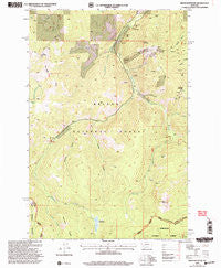
~ Bison Mountain MT topo map, 1:24000 scale, 7.5 X 7.5 Minute, Historical, 2001, updated 2004
Bison Mountain, Montana, USGS topographic map dated 2001.
Includes geographic coordinates (latitude and longitude). This topographic map is suitable for hiking, camping, and exploring, or framing it as a wall map.
Printed on-demand using high resolution imagery, on heavy weight and acid free paper, or alternatively on a variety of synthetic materials.
Topos available on paper, Waterproof, Poly, or Tyvek. Usually shipping rolled, unless combined with other folded maps in one order.
- Product Number: USGS-5391490
- Free digital map download (high-resolution, GeoPDF): Bison Mountain, Montana (file size: 15 MB)
- Map Size: please refer to the dimensions of the GeoPDF map above
- Weight (paper map): ca. 55 grams
- Map Type: POD USGS Topographic Map
- Map Series: HTMC
- Map Verison: Historical
- Cell ID: 4039
- Scan ID: 262512
- Imprint Year: 2004
- Woodland Tint: Yes
- Aerial Photo Year: 1995
- Datum: NAD27
- Map Projection: Lambert Conformal Conic
- Map published by United States Forest Service
- Map Language: English
- Scanner Resolution: 600 dpi
- Map Cell Name: Bison Mountain
- Grid size: 7.5 X 7.5 Minute
- Date on map: 2001
- Map Scale: 1:24000
- Geographical region: Montana, United States
Neighboring Maps:
All neighboring USGS topo maps are available for sale online at a variety of scales.
Spatial coverage:
Topo map Bison Mountain, Montana, covers the geographical area associated the following places:
- Mountain View Mine - Irish Mine Hill - SE SW Section 8 Mine - Sawmill Creek - Forbidding Ridge - Monarch Mill Site - Bison Mountain - Monarch Mine - Orphan Widow Mine - Connors Gulch - SE NW Section 12 Mine - SW SE Section 1 Mine - Larabee Gulch - Negros Mine - Viking Mine - Monarch Creek - Mary Ann Creek - Hat Creek - Treasure Mountain - Golden Anchor Mine - Big Dick Mine - No Grass Creek - Julia Mine - Charter Oak Mines - Kading Ranger Station - Ontario Creek - Monarch Mine - Golden Anchor Mine - SW NE Section 12 Mine - Limburger Spring - NE NW Section 12 Mine - SW NW Section 20 Mine - Negro Mountain - NE NW Section 6 Mine - Blackfoot Meadows - Charlesburg Post Office (historical) - Charter Oak Mine - Baldy Ridge - Julia Mine - Kimball Mine
- Map Area ID: AREA46.546.375-112.5-112.375
- Northwest corner Lat/Long code: USGSNW46.5-112.5
- Northeast corner Lat/Long code: USGSNE46.5-112.375
- Southwest corner Lat/Long code: USGSSW46.375-112.5
- Southeast corner Lat/Long code: USGSSE46.375-112.375
- Northern map edge Latitude: 46.5
- Southern map edge Latitude: 46.375
- Western map edge Longitude: -112.5
- Eastern map edge Longitude: -112.375


