
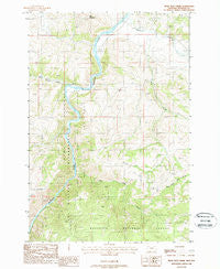
~ Bear Trap Creek MT topo map, 1:24000 scale, 7.5 X 7.5 Minute, Historical, 1988, updated 1988
Bear Trap Creek, Montana, USGS topographic map dated 1988.
Includes geographic coordinates (latitude and longitude). This topographic map is suitable for hiking, camping, and exploring, or framing it as a wall map.
Printed on-demand using high resolution imagery, on heavy weight and acid free paper, or alternatively on a variety of synthetic materials.
Topos available on paper, Waterproof, Poly, or Tyvek. Usually shipping rolled, unless combined with other folded maps in one order.
- Product Number: USGS-5391112
- Free digital map download (high-resolution, GeoPDF): Bear Trap Creek, Montana (file size: 13 MB)
- Map Size: please refer to the dimensions of the GeoPDF map above
- Weight (paper map): ca. 55 grams
- Map Type: POD USGS Topographic Map
- Map Series: HTMC
- Map Verison: Historical
- Cell ID: 69287
- Scan ID: 262321
- Imprint Year: 1988
- Woodland Tint: Yes
- Aerial Photo Year: 1981
- Edit Year: 1988
- Field Check Year: 1984
- Datum: NAD27
- Map Projection: Lambert Conformal Conic
- Provisional map: Yes
- Map published by United States Geological Survey
- Map Language: English
- Scanner Resolution: 600 dpi
- Map Cell Name: Bear Trap Creek
- Grid size: 7.5 X 7.5 Minute
- Date on map: 1988
- Map Scale: 1:24000
- Geographical region: Montana, United States
Neighboring Maps:
All neighboring USGS topo maps are available for sale online at a variety of scales.
Spatial coverage:
Topo map Bear Trap Creek, Montana, covers the geographical area associated the following places:
- 03S01E02BDC_01 Well - Moore Ranch Number 3 Mine - NE NW Section 21 Mine - Lee Metcalf Wilderness - Madison River Bridge - Cherry Creek School (historical) - Cold Spring Creek - Ferry Landing Historic Site - Bear Trap Creek Number 2 Mine - Copper King Mine - Hot Springs Creek - Cherry Creek - Beartrap Recreation Area - Moore Ranch Number 2 Mine - NE SE Section 21 Mine - Moore Ranch Number 1 Mine - NE NW Section 28 Mine - Lewis Post Office (historical) - NW NE Section 15 Mine - Stephens Ranch - Bear Trap Creek - Pole Creek - Bear Trap Creek Mine - Savannah Ridge Mine - Red Mountain - Morning Star Mine
- Map Area ID: AREA45.62545.5-111.625-111.5
- Northwest corner Lat/Long code: USGSNW45.625-111.625
- Northeast corner Lat/Long code: USGSNE45.625-111.5
- Southwest corner Lat/Long code: USGSSW45.5-111.625
- Southeast corner Lat/Long code: USGSSE45.5-111.5
- Northern map edge Latitude: 45.625
- Southern map edge Latitude: 45.5
- Western map edge Longitude: -111.625
- Eastern map edge Longitude: -111.5


