
~ Wilmington DE topo map, 1:250000 scale, 1 X 2 Degree, Historical, 1966, updated 1979
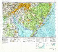
Wilmington, Delaware, USGS topographic map dated 1966.
Includes geographic coordinates (latitude and longitude). This topographic map is suitable for hiking, camping, and exploring, or framing it as a wall map.
Printed on-demand using high resolution imagery, on heavy weight and acid free paper, or alternatively on a variety of synthetic materials.
Topos available on paper, Waterproof, Poly, or Tyvek. Usually shipping rolled, unless combined with other folded maps in one order.
- Product Number: USGS-5390404
- Free digital map download (high-resolution, GeoPDF): Wilmington, Delaware (file size: 24 MB)
- Map Size: please refer to the dimensions of the GeoPDF map above
- Weight (paper map): ca. 55 grams
- Map Type: POD USGS Topographic Map
- Map Series: HTMC
- Map Verison: Historical
- Cell ID: 69102
- Scan ID: 255826
- Imprint Year: 1979
- Woodland Tint: Yes
- Edit Year: 1972
- Field Check Year: 1966
- Datum: NAD27
- Map Projection: Transverse Mercator
- Map published by United States Army
- Map Language: English
- Scanner Resolution: 600 dpi
- Map Cell Name: Wilmington
- Grid size: 1 X 2 Degree
- Date on map: 1966
- Map Scale: 1:250000
- Geographical region: Delaware, United States
Neighboring Maps:
All neighboring USGS topo maps are available for sale online at a variety of scales.
Spatial coverage:
Topo map Wilmington, Delaware, covers the geographical area associated the following places:
- Meriweather Farms - Marplewood Villa - North Port Norris - Reynard Crossing - Wyoming Mills - Kingston Estates - Evesboro - Kimberton - Five Points - Taylor Estates - Newtonville - Shirley - Cedar Hill - Loveville - Meadow Glen - Elk Neck - Barnsboro - Todd Estates - Green Ridge - Trepagnier - Llangollen Estates - Armstrong - Havertown - Pleasant Cove - Seaville - Chester - Nesco - Chester Heights - Wenonah - Claymont Terrace - Coffins Corner - Laurel Springs - Othello - Gander Hill - Chatwood - Pine Hills - Stanwick Glen - Eayrestown - Mount Cuba - Holloway Terrace - South Penns Grove - Caravel Farms - Cropwell - Glen Farms - Merion Gardens - Princeton Estates - Paynters Crossing - Ogletown - Romansville - Dover Forge - Bamber Lake - West Farm - Wooddale - Ardmore Park - Collings Lakes - Atco - McClellandville - Speedwell - Chester Plaza - Normandy Manor - Hickory Hill - Penn Place - Washington Heights - Viola Woods - Seven Hickories - Strasburg Court - Felton Heights - Limestone Acres - Beach Haven Gardens - Presidential Lake Estates - Goshen Commons - Eagleswood Village - Atsion - Osage - Granada Mobile Home Park - Chesilhurst - Melody Meadows II - Crowfoot - Penns Grove - Cedar Grove - Lindenwold - Black Horse - Kaolin - Hockessin Park - Heather Woods - McDaniel Heights - Pin Oak Farms - Parkridge at Bellevue - Beach Haven Terrace - Germania Gardens - Robanna - Spray Beach - Boothwyn - Upper Octoraro - Crystal Run Farm - Auburn - Lindamere - Penfield - Peacedale - Five Points
- Map Area ID: AREA4039-76-74
- Northwest corner Lat/Long code: USGSNW40-76
- Northeast corner Lat/Long code: USGSNE40-74
- Southwest corner Lat/Long code: USGSSW39-76
- Southeast corner Lat/Long code: USGSSE39-74
- Northern map edge Latitude: 40
- Southern map edge Latitude: 39
- Western map edge Longitude: -76
- Eastern map edge Longitude: -74


