
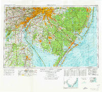
~ Wilmington DE topo map, 1:250000 scale, 1 X 2 Degree, Historical, 1972, updated 1976
Wilmington, Delaware, USGS topographic map dated 1972.
Includes geographic coordinates (latitude and longitude). This topographic map is suitable for hiking, camping, and exploring, or framing it as a wall map.
Printed on-demand using high resolution imagery, on heavy weight and acid free paper, or alternatively on a variety of synthetic materials.
Topos available on paper, Waterproof, Poly, or Tyvek. Usually shipping rolled, unless combined with other folded maps in one order.
- Product Number: USGS-5390400
- Free digital map download (high-resolution, GeoPDF): Wilmington, Delaware (file size: 23 MB)
- Map Size: please refer to the dimensions of the GeoPDF map above
- Weight (paper map): ca. 55 grams
- Map Type: POD USGS Topographic Map
- Map Series: HTMC
- Map Verison: Historical
- Cell ID: 69102
- Scan ID: 255824
- Imprint Year: 1976
- Woodland Tint: Yes
- Edit Year: 1972
- Field Check Year: 1966
- Datum: Unstated
- Map Projection: Transverse Mercator
- Map published by United States Army
- Map Language: English
- Scanner Resolution: 600 dpi
- Map Cell Name: Wilmington
- Grid size: 1 X 2 Degree
- Date on map: 1972
- Map Scale: 1:250000
- Geographical region: Delaware, United States
Neighboring Maps:
All neighboring USGS topo maps are available for sale online at a variety of scales.
Spatial coverage:
Topo map Wilmington, Delaware, covers the geographical area associated the following places:
- McClellandville - Scotch Bonnet - Bristle Knoll - Mechanicsville - Surrey Park - Caln - Wrightsville - Bush Manor - Creesville - Shaws Corner - Lincoln Park - Wellington Park - Wynn Wood - Wawaset - Centre City - Ogletown - Vernon - Gardiners Landing - Duross Heights - Penarth - Springton Point Estates - Holletts Corners - Seabrook Farms - Worington Commons - Fostertown - Bowentown - Mill Creek - Batsto - Montchan - Whitehall Landing - Edgemoor - Heatherton - Spring Oak - Wellington Hills - Meadowbrook - Holiday Heights - Scrapetown - Mickles Mill - Westtown Acres - Cedar Beach - Georgetown - Odessa - Wawa - Delmont - Grandview Meadows - Edenton - Grand Meadows - Silver Beach - Fairway Falls - Cristine Manor - Dicktown - Pointers - Crowfoot - Lindenwold - Cecil Manor - Hesstown - Deerfield - Tioga Park - Busic - Pin Oak Farms - Claymont Village - West Collingswood - Broad Lane - Bortondale - Beaver Valley - Loveladies - Talcose - Danceys Corner - Salem Village - Wood Mill - Pearsons Corner - Eden Park Gardens - Airmont Acres - Waterford Works - Snow Hill - Little Creek Landing - Bon Air - Southwood Acres Mobile Home Park - Tindells Landing - Walker - Riddleton - Tara - Surrey Ridge - Elk Ranch Park - Burmont - Brookewood Cove - Faulkland Woods - Massey - Clermont - Spraguetown - Bennys Landing - Cherry Wood - Springton Pointe Woods - Cherry Hill Estates - Stottsville - Westtown - Parry - High Crossing - Berlin Heights - Concord Hunt
- Map Area ID: AREA4039-76-74
- Northwest corner Lat/Long code: USGSNW40-76
- Northeast corner Lat/Long code: USGSNE40-74
- Southwest corner Lat/Long code: USGSSW39-76
- Southeast corner Lat/Long code: USGSSE39-74
- Northern map edge Latitude: 40
- Southern map edge Latitude: 39
- Western map edge Longitude: -76
- Eastern map edge Longitude: -74


