
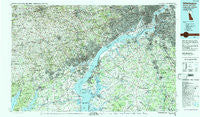
~ Wilmington DE topo map, 1:100000 scale, 30 X 60 Minute, Historical, 1984, updated 1988
Wilmington, Delaware, USGS topographic map dated 1984.
Includes geographic coordinates (latitude and longitude). This topographic map is suitable for hiking, camping, and exploring, or framing it as a wall map.
Printed on-demand using high resolution imagery, on heavy weight and acid free paper, or alternatively on a variety of synthetic materials.
Topos available on paper, Waterproof, Poly, or Tyvek. Usually shipping rolled, unless combined with other folded maps in one order.
- Product Number: USGS-5390382
- Free digital map download (high-resolution, GeoPDF): Wilmington, Delaware (file size: 37 MB)
- Map Size: please refer to the dimensions of the GeoPDF map above
- Weight (paper map): ca. 55 grams
- Map Type: POD USGS Topographic Map
- Map Series: HTMC
- Map Verison: Historical
- Cell ID: 68598
- Scan ID: 255819
- Imprint Year: 1988
- Woodland Tint: Yes
- Aerial Photo Year: 1982
- Edit Year: 1984
- Datum: NAD27
- Map Projection: Universal Transverse Mercator
- Map published by United States Geological Survey
- Map Language: English
- Scanner Resolution: 600 dpi
- Map Cell Name: Wilmington
- Grid size: 30 X 60 Minute
- Date on map: 1984
- Map Scale: 1:100000
- Geographical region: Delaware, United States
Neighboring Maps:
All neighboring USGS topo maps are available for sale online at a variety of scales.
Spatial coverage:
Topo map Wilmington, Delaware, covers the geographical area associated the following places:
- Woods at Sweetwater - Stirrup Farms - Cossart - Old City - Central Square - Oldmans - Cheyney - Bank (historical) - Cameron Hills - Henderson Heights - Drummond Ridge - Aldine - Memel Farms - Rose Tree - Greenshire - Horseshoe Hill - Pedricktown - Blue Hill - Stoneridge - Foxcatcher at Fair Hill - North Bluff - Wrights Mill - Madelyn Gardens - Weldin Farms - Delaware Heights - Larchmont Square - Saint Johns Manor - Mower - Mortonville - Edgemoor - Blue Rock Manor - Glenhall - Cohansey - Analine Village - Old Mill Pointe - Weber Tract - Tailwinds Estates - Penns Beach - Ludlow - The Village of Drummond Hill - Riverside Addition - Westminster - Cherry Wood - Church Landing - Claymont Heights - Grand Sprute - Quaker Hill - Beech Hill - East Camden - Century Farms - Pennwood South - Marshallton - Wylie Farms - Woodshade - Wawaset Park - White Chimneys - Mill Creek - Lum Estates - Airmont Acres - Fort Elfsborg - Duncan Glen - Webster Farm - Sheffield Manor - Pendrew Manor - Hickory Hill - Ferrell - Lyndalia - Mitchell Estates - Normira Heights - Cokesbury Village - Village Green - Bellevue - Quails Nest - Stottsville - West Goshen - Yorktown - Amaranth - Hockessin Hunt - Greenville Place - Coventry Crossing - Norway - Leeds - Village of Valleybrook - Mount Ephraim - Saint Albans - Delaire - Garden City - Manette Heights - Arden - Passyunk Homes - Llanwellyn - Woodlyn - Alverno Valley Farms - Heather Valley - Westinghouse Village - Point Airy - Runnymeade - Hillcrest - Ogden - Ardencroft
- Map Area ID: AREA4039.5-76-75
- Northwest corner Lat/Long code: USGSNW40-76
- Northeast corner Lat/Long code: USGSNE40-75
- Southwest corner Lat/Long code: USGSSW39.5-76
- Southeast corner Lat/Long code: USGSSE39.5-75
- Northern map edge Latitude: 40
- Southern map edge Latitude: 39.5
- Western map edge Longitude: -76
- Eastern map edge Longitude: -75


