
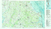
~ Seaford DE topo map, 1:100000 scale, 30 X 60 Minute, Historical, 1984, updated 1988
Seaford, Delaware, USGS topographic map dated 1984.
Includes geographic coordinates (latitude and longitude). This topographic map is suitable for hiking, camping, and exploring, or framing it as a wall map.
Printed on-demand using high resolution imagery, on heavy weight and acid free paper, or alternatively on a variety of synthetic materials.
Topos available on paper, Waterproof, Poly, or Tyvek. Usually shipping rolled, unless combined with other folded maps in one order.
- Product Number: USGS-5390378
- Free digital map download (high-resolution, GeoPDF): Seaford, Delaware (file size: 26 MB)
- Map Size: please refer to the dimensions of the GeoPDF map above
- Weight (paper map): ca. 55 grams
- Map Type: POD USGS Topographic Map
- Map Series: HTMC
- Map Verison: Historical
- Cell ID: 68336
- Scan ID: 255816
- Imprint Year: 1988
- Woodland Tint: Yes
- Visual Version Number: 2
- Aerial Photo Year: 1981
- Edit Year: 1984
- Datum: NAD27
- Map Projection: Universal Transverse Mercator
- Map published by United States Geological Survey
- Map Language: English
- Scanner Resolution: 600 dpi
- Map Cell Name: Seaford
- Grid size: 30 X 60 Minute
- Date on map: 1984
- Map Scale: 1:100000
- Geographical region: Delaware, United States
Neighboring Maps:
All neighboring USGS topo maps are available for sale online at a variety of scales.
Spatial coverage:
Topo map Seaford, Delaware, covers the geographical area associated the following places:
- Bay Harbor - Asbury - Bayard - Double Hills Estates - Cabin Creek Estates - The Reservation - Buckels Corner - Sea Air Mobile Home Park - Reliance - Hicksburg - Scotts Corner - Millpond Acres - Greentop - Mobile Gardens Mobile Home Park - Bay Shore Mobile Home Park - Shady Ridge - Broad Creek Estates - Staytonville - Bennum - Seabreeze - Colony West - Brookview - Milford - The Landing - Pealiquor Landing - Hoagland Subdivision - Dogwood Park Mobile Home Park - Bradleysburg (historical) - Whiteleysburg - Bureau - Bloomfield Acres - Tuckahoe Springs - Smith Landing - Irons Lane Landing - Argo Corners - Middleford - Land of Pleasant Living - Broadkill Beach - Edwardsville - Heritage Village - Passapae Landing - Mispillion Light - Wings Landing - Belmont Acres - Bryan Park - White Creek Manor - Murrays Development - Windyhill - Harmony - Blackwater - Nassau Park Mobile Home Park - Holiday Acres - Robertson Landing - Ruth Harbor - Midway Park Subdivision - Heronwood - Boyers Village - Choptank - Blackwater Village - Matthews - D and K Mobile Home Park - The Island - Hurlock - Bank Harbor Retreat - Scottsdale Park Mobile Home Park - Roesville - Gulls Nest - Indian Mission - Country Village - Meadow Acres - Arabian Acres - Piney Grove Manor - Conley Chapel Village Mobile Home Park - County Seat Gardens Mobile Home Park - Stafford Heights - The Plantations - Sherwood Forest Mobile Home Park - The Oaks - Patterson Place Mobile Home Park - Carsylian Acres - Seabreak - Omar - Henlopen Keys - Long Acres - Robinsonville - West Denton - Pine Lake Development - New Hope - Herring Creek Estates - Chapel Woods - Dewey Beach - Southside Trailer Park - Pusey Crossroads - Wooded Acres - Cantebury Apartments - Colonial East Mobile Home Park - Mill Run Acres - Holly Hill - Redden - Angola by the Bay
- Map Area ID: AREA3938.5-76-75
- Northwest corner Lat/Long code: USGSNW39-76
- Northeast corner Lat/Long code: USGSNE39-75
- Southwest corner Lat/Long code: USGSSW38.5-76
- Southeast corner Lat/Long code: USGSSE38.5-75
- Northern map edge Latitude: 39
- Southern map edge Latitude: 38.5
- Western map edge Longitude: -76
- Eastern map edge Longitude: -75


