
~ Dover DE topo map, 1:100000 scale, 30 X 60 Minute, Historical, 1984, updated 1985
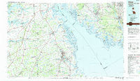
Dover, Delaware, USGS topographic map dated 1984.
Includes geographic coordinates (latitude and longitude). This topographic map is suitable for hiking, camping, and exploring, or framing it as a wall map.
Printed on-demand using high resolution imagery, on heavy weight and acid free paper, or alternatively on a variety of synthetic materials.
Topos available on paper, Waterproof, Poly, or Tyvek. Usually shipping rolled, unless combined with other folded maps in one order.
- Product Number: USGS-5390376
- Free digital map download (high-resolution, GeoPDF): Dover, Delaware (file size: 23 MB)
- Map Size: please refer to the dimensions of the GeoPDF map above
- Weight (paper map): ca. 55 grams
- Map Type: POD USGS Topographic Map
- Map Series: HTMC
- Map Verison: Historical
- Cell ID: 67433
- Scan ID: 255815
- Imprint Year: 1985
- Woodland Tint: Yes
- Aerial Photo Year: 1981
- Edit Year: 1984
- Datum: NAD27
- Map Projection: Universal Transverse Mercator
- Map published by United States Geological Survey
- Map Language: English
- Scanner Resolution: 600 dpi
- Map Cell Name: Dover
- Grid size: 30 X 60 Minute
- Date on map: 1984
- Map Scale: 1:100000
- Geographical region: Delaware, United States
Neighboring Maps:
All neighboring USGS topo maps are available for sale online at a variety of scales.
Spatial coverage:
Topo map Dover, Delaware, covers the geographical area associated the following places:
- Lakewind - Derbywood - Spruance City - Haleyville - Northridge - Baileytown - Wheatleys Pond - Char-Nor Manor - Fithians Corner - Concord (historical) - Cassidy Wharf - Felton Heights - Cash Corner (historical) - Locust Grove - Ryans Run - Green Briar - Mallards Run - Bohemia Acres - Shaws Mill - Shorewood - Baltimore Corner - Mahan - Beachwood Glen - Frenchs Mobile Homes - Union Corner - Kirby Landing - Manchester Square - Colmar Manor - Harmersville - Busic - Evergreen Farms - Clayville - Wrights Crossroads - Townsend - Shell Pile - John Town - Pondtown - Rolling Meadows - El Dondo Acres - Pine Island - Hughes Crossing - Hacks Point Acres - Silver Maple Mobile Home Park - Wedgewood - Bivalve - Woodbrook - Stave Landing - Bethesda - Gander Hill - Rising Sun - Fairton - Dupont - Green Spring Farm - Choptank Pines - Massey - Forest - Woods Manor East - Townsend Fields - Towne Point - Whitehall Landing - Pleasanton Acres - Greenview - Snow Hill (historical) - Deans Meadows - Forrest Grove Village Mobile Home Park - Heatherfield - Vineland - Candlewicke - Pinewood Acres Mobile Home Park - Dividing Creek - Capitol Park - Newport Landing - Bethel - Carter Development - Wooden Bridge - Lebanon - Cleavers Corner - Woodfield - Bechers Brook - Maskells Mill - Marlboro - Glencoe - Brenford - Campbells Corner - Daniels Tract - Hidden Pond - Huntley - Shorts Corner - The Hamlet - Rose Valley Estates - Deep Branch Farm - Ewingville - Husted Landing - Canton - Garton - Barkers Landing - Briar Park - High Point Mobile Home Park - Meadow Ridge - Tindells Landing
- Map Area ID: AREA39.539-76-75
- Northwest corner Lat/Long code: USGSNW39.5-76
- Northeast corner Lat/Long code: USGSNE39.5-75
- Southwest corner Lat/Long code: USGSSW39-76
- Southeast corner Lat/Long code: USGSSE39-75
- Northern map edge Latitude: 39.5
- Southern map edge Latitude: 39
- Western map edge Longitude: -76
- Eastern map edge Longitude: -75


