
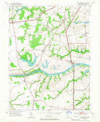
~ Saint Georges DE topo map, 1:24000 scale, 7.5 X 7.5 Minute, Historical, 1953, updated 1967
Saint Georges, Delaware, USGS topographic map dated 1953.
Includes geographic coordinates (latitude and longitude). This topographic map is suitable for hiking, camping, and exploring, or framing it as a wall map.
Printed on-demand using high resolution imagery, on heavy weight and acid free paper, or alternatively on a variety of synthetic materials.
Topos available on paper, Waterproof, Poly, or Tyvek. Usually shipping rolled, unless combined with other folded maps in one order.
- Product Number: USGS-5390172
- Free digital map download (high-resolution, GeoPDF): Saint Georges, Delaware (file size: 9 MB)
- Map Size: please refer to the dimensions of the GeoPDF map above
- Weight (paper map): ca. 55 grams
- Map Type: POD USGS Topographic Map
- Map Series: HTMC
- Map Verison: Historical
- Cell ID: 76623
- Scan ID: 255639
- Imprint Year: 1967
- Woodland Tint: Yes
- Aerial Photo Year: 1951
- Field Check Year: 1953
- Datum: NAD27
- Map Projection: Polyconic
- Map published by United States Geological Survey
- Map Language: English
- Scanner Resolution: 600 dpi
- Map Cell Name: Saint Georges
- Grid size: 7.5 X 7.5 Minute
- Date on map: 1953
- Map Scale: 1:24000
- Geographical region: Delaware, United States
Neighboring Maps:
All neighboring USGS topo maps are available for sale online at a variety of scales.
Spatial coverage:
Topo map Saint Georges, Delaware, covers the geographical area associated the following places:
- Biddles Corner - Lorewood Grove - Saint Georges Heights - Keeney - Moores Acres - Becks Landing - Airmont Acres - Pine Valley Farms - Melody Meadows - Lauren Farms - Reybold - Shenandoah - Caravel Farms - Meadowbrook Farms South - Kirkwood - Four Seasons Park - Rolling Meadows - Woodside Manor - Porter - Glasgow Pines - Tolham Estates - Countryside Farms - Porter Square - Saint Georges - Williamsburg - Kinston Acres - Dragon Run Terrace Mobile Home Park - Meadowbrook Farms - Summit Bridge - Mount Pleasant Mobile Home Park - Dutch Neck Farms - Garwood Estates - Mount Pleasant - Clay Acres - Parkside - Kings Croft - Belltown Woods - Boyds Corner - Birds Corner - Corbit - Crystal Run Farm - Glasgow - Hickory Woods - Red Lion - Glasgow Court - Lums Pond Estates II - Marabou Meadows - Melody Meadows II - Little Jersey - Gams Crest - Wrangle Hill - Wrange Hill Estates - Jamisons Corner - Tybouts Corner
- Map Area ID: AREA39.62539.5-75.75-75.625
- Northwest corner Lat/Long code: USGSNW39.625-75.75
- Northeast corner Lat/Long code: USGSNE39.625-75.625
- Southwest corner Lat/Long code: USGSSW39.5-75.75
- Southeast corner Lat/Long code: USGSSE39.5-75.625
- Northern map edge Latitude: 39.625
- Southern map edge Latitude: 39.5
- Western map edge Longitude: -75.75
- Eastern map edge Longitude: -75.625


