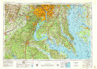
~ Washington DC topo map, 1:250000 scale, 1 X 2 Degree, Historical, 1957, updated 1979
Washington, District of Columbia, USGS topographic map dated 1957.
Includes geographic coordinates (latitude and longitude). This topographic map is suitable for hiking, camping, and exploring, or framing it as a wall map.
Printed on-demand using high resolution imagery, on heavy weight and acid free paper, or alternatively on a variety of synthetic materials.
Topos available on paper, Waterproof, Poly, or Tyvek. Usually shipping rolled, unless combined with other folded maps in one order.
- Product Number: USGS-5389876
- Free digital map download (high-resolution, GeoPDF): Washington, District of Columbia (file size: 21 MB)
- Map Size: please refer to the dimensions of the GeoPDF map above
- Weight (paper map): ca. 55 grams
- Map Type: POD USGS Topographic Map
- Map Series: HTMC
- Map Verison: Historical
- Cell ID: 69087
- Scan ID: 707671
- Imprint Year: 1979
- Woodland Tint: Yes
- Visual Version Number: 1
- Aerial Photo Year: 1976
- Edit Year: 1979
- Field Check Year: 1957
- Datum: NAD27
- Map Projection: Transverse Mercator
- Map published by United States Geological Survey
- Map published by: Military, Other
- Map Language: English
- Scanner Resolution: 508 dpi
- Map Cell Name: Washington
- Grid size: 1 X 2 Degree
- Date on map: 1957
- Map Scale: 1:250000
- Geographical region: District of Columbia, United States
Neighboring Maps:
All neighboring USGS topo maps are available for sale online at a variety of scales.
Spatial coverage:
Topo map Washington, District of Columbia, covers the geographical area associated the following places:
- Green Acres - Chevy Chase Manor - Cornwell - Tucker Hill - Woodridge Acres - North Roblee Acres - Saint Leonard (historical) - Japazaws - Nostalgia - Watergate Village - Smiths Mill - Settlers Landing - Thorny Point Farm - Cedar Cove - Langley - Woodridge - Presidential Lakes - Hunting Lake - Abell - Indian Creek Estates - The Sage - Forest Hills - Copperville - Old Villa - Featherstone - Chesterbrook - Kings Landing - Papas - Maple Grove - Queen Anne Colony - Rays Point - Jefferson - College Park - Bataan Village - Springfield Square - Quiet Meadows - Tauxenent (historical) - Park Estates - Fairfax Acres - Great Falls - Monroe Hall - Brooks - South Haven - Sudley - Mosby Woods - Cookes Park - Westgate - Sylvania Heights - Summerwind - Pinemore - Loch Lomond - Takoma Park - Brannock Cove - Dalecrest - The Meadows - Bay View Heights - Bald Eagle Hills - Mount Pleasant - Burns Crossroads - Docstone Commons - Saint Inigoes Shores - Holt Manor - Carters Corner - Honga - Stallings - Kellys Ford - Wilson (historical) - Ridgedale - Rosemont - Montrose - Bel Air - Rolling View - Shady Hill - Cedar Lawn - Congress Park - Colchester - Watson - East Riverdale - Glassmanor - Highland Park - Grace Creek - Scientists Cliffs - Bowie - Hallmark Woods - Hollywood Shores - Saint Marys City - Antioch Fork - Old Annapolis Neck - Garrisons Corners (historical) - Buena Vista on the Patuxent - Piscataway Hills - Harkness Creek Park - Clinton Heights - Brookwood Acres - Fairlawn - Westboro - Pleasant Grove Estates - Ryceville - Webbs Corner - North Brentwood
- Map Area ID: AREA3938-78-76
- Northwest corner Lat/Long code: USGSNW39-78
- Northeast corner Lat/Long code: USGSNE39-76
- Southwest corner Lat/Long code: USGSSW38-78
- Southeast corner Lat/Long code: USGSSE38-76
- Northern map edge Latitude: 39
- Southern map edge Latitude: 38
- Western map edge Longitude: -78
- Eastern map edge Longitude: -76