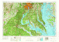
~ Washington DC topo map, 1:250000 scale, 1 X 2 Degree, Historical, 1957, updated 1966
Washington, District of Columbia, USGS topographic map dated 1957.
Includes geographic coordinates (latitude and longitude). This topographic map is suitable for hiking, camping, and exploring, or framing it as a wall map.
Printed on-demand using high resolution imagery, on heavy weight and acid free paper, or alternatively on a variety of synthetic materials.
Topos available on paper, Waterproof, Poly, or Tyvek. Usually shipping rolled, unless combined with other folded maps in one order.
- Product Number: USGS-5389868
- Free digital map download (high-resolution, GeoPDF): Washington, District of Columbia (file size: 23 MB)
- Map Size: please refer to the dimensions of the GeoPDF map above
- Weight (paper map): ca. 55 grams
- Map Type: POD USGS Topographic Map
- Map Series: HTMC
- Map Verison: Historical
- Cell ID: 69087
- Scan ID: 257787
- Imprint Year: 1966
- Woodland Tint: Yes
- Edit Year: 1963
- Datum: Unstated
- Map Projection: Transverse Mercator
- Map published by United States Geological Survey
- Map Language: English
- Scanner Resolution: 600 dpi
- Map Cell Name: Washington
- Grid size: 1 X 2 Degree
- Date on map: 1957
- Map Scale: 1:250000
- Geographical region: District of Columbia, United States
Neighboring Maps:
All neighboring USGS topo maps are available for sale online at a variety of scales.
Spatial coverage:
Topo map Washington, District of Columbia, covers the geographical area associated the following places:
- Woodland Acres - Green Manor Estates - Franklin Manor-on-the-Bay - Buena Vista Hills - Mine Ridge - Bent Tree Estates - Howards Corner - East Falls Church - Old Villa - Lloyds - Liberty Place - Harmony Hall - Kent Timbers - Market Quay - Terrapin Forest - Farragut Square - Woods of Able Lake - Jomar Acres - Colvin Farms - Sleepy Hollow - Colebrooke - Manassas - Almar Estates - Pohick - Brookdale - Bryantown Hills - Riverdale Gardens - Cedar Heights - Woodley Hills - Morrisons Corner - Greenbriar - Aquia Overlook - Meadow Woods Estates - Mecklenburg - Tuxedo Colony - Haymarket - Heartland Ridge - Westphalia Estates - Montross - Montclair - Hunters Ridge - Cactus Hill - Pawpaw Hollow - Garrisons Corners (historical) - Buckler Trailer Park - Saunders Point - Gingerville Manor Estates - Berea Plantation - Montrose - Sleepy Hollow - Mount Air - Mayfair-Parkside - Arlington Heights - Chevy Chase - Green Meadows - Smoky - Independent Hill - Sudley Mountain Estates - Rogers Heights - Marshall Heights - Spencers Wharf - Kettering - Windcliff - Goldvein - Eastport - Quiet Woods Estate - Berry Hill Estates - Fort Davis - Middleton Farm - Iron Gate - Lake of the Pines - Blaisdell Subdivision - Persimmon Hills - Maryland Manor - Chesapeake Station - Michigan Park Hills - Locklears Landing - Milltown Landing - Rio Vista - Woodburn - Clarks Run - Fernwood Mobile Home Park - Brighton Woods - Lavall Woods - Walden Ten - Cedarville Mobile Home Park - Cove View - The Greens of Crofton - Carthagena Creek - Mount Pleasant - Harbor Hills - Hampshire Knolls - Clinton Woods - Holly Run Estates - Halfway - Mount Vernon Square - Westover Place - Stafford - Mayo - Amys Acres
- Map Area ID: AREA3938-78-76
- Northwest corner Lat/Long code: USGSNW39-78
- Northeast corner Lat/Long code: USGSNE39-76
- Southwest corner Lat/Long code: USGSSW38-78
- Southeast corner Lat/Long code: USGSSE38-76
- Northern map edge Latitude: 39
- Southern map edge Latitude: 38
- Western map edge Longitude: -78
- Eastern map edge Longitude: -76