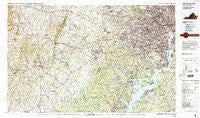
~ Washington West DC topo map, 1:100000 scale, 30 X 60 Minute, Historical, 1986, updated 1986
Washington West, District of Columbia, USGS topographic map dated 1986.
Includes geographic coordinates (latitude and longitude). This topographic map is suitable for hiking, camping, and exploring, or framing it as a wall map.
Printed on-demand using high resolution imagery, on heavy weight and acid free paper, or alternatively on a variety of synthetic materials.
Topos available on paper, Waterproof, Poly, or Tyvek. Usually shipping rolled, unless combined with other folded maps in one order.
- Product Number: USGS-5389856
- Free digital map download (high-resolution, GeoPDF): Washington West, District of Columbia (file size: 38 MB)
- Map Size: please refer to the dimensions of the GeoPDF map above
- Weight (paper map): ca. 55 grams
- Map Type: POD USGS Topographic Map
- Map Series: HTMC
- Map Verison: Historical
- Cell ID: 76846
- Scan ID: 255914
- Imprint Year: 1986
- Woodland Tint: Yes
- Visual Version Number: 2
- Aerial Photo Year: 1984
- Edit Year: 1986
- Datum: NAD27
- Map Projection: Universal Transverse Mercator
- Map published by United States Geological Survey
- Map Language: English
- Scanner Resolution: 600 dpi
- Map Cell Name: Washington West
- Grid size: 30 X 60 Minute
- Date on map: 1986
- Map Scale: 1:100000
- Geographical region: District of Columbia, United States
Neighboring Maps:
All neighboring USGS topo maps are available for sale online at a variety of scales.
Spatial coverage:
Topo map Washington West, District of Columbia, covers the geographical area associated the following places:
- Boxwood Farms - Glenwood - Rosemont - Columbia Pines - Tremont Gardens - Marumsco Acres - Harlem (historical) - Villamay - Georgetown South - Ravensworth Park - Catharpin - Wakefield - Jermantown - Millards Mill - Marbury - Colony Woods - Brookmont - Georgetown Village - Bren Mar Park - Fort Barnard Heights - Edgewood - Sudley Springs - Germantown - Dupont Circle - Forestdale - Rectortown - Devonshire Gardens - Mockingbird Ridge - Cooktown - Elk Run - Springfield - Matildaville (historical) - Westhampton - Loch Lomond - Tall Trees Estates - Forest Lake Estates - Sunset Manor - London Towne - Hunters Grove Estates - Foxhall - Waldon Woods - Franconia - Minnieville Manor - Ashton Glen - Jacksontown - Sligo - Lord Fairfax Estates - Dumfries - Featherstone - Canova - Chapman Landing - Armsleigh Park (historical) - Colchester Acres - Marsh Run Mobile Home Park - Belvedere - Holmes Run Park - Cannon - Fairfax Park - Strathmeade Springs - College Park - Fairlee - Bristow - Snow Hill - Broad Run Village - Enola - Green Acres - Fairfax Acres - Quantico - River Ridge Estates - Broyhill Crest - Deerfield Estates - Farragut Square - Glenmere - Morningside - Fairfax Woods - Bucknell Manor - Fairview - Westchester - Burns Crossroads - Oxfordshire - River Oaks - Woodhaven - New Alexandria - Waterfall - Cloverdale - Broken Hill - Buzzard Point - Parkview Hills - Falls Hill - Rock Hill - Forest Hills - Willow Run - Carroll Manor - Beverley Hills - Mount Vernon Square - Franklin Forest - Woodley North - Baileys Crossroads - Rutherford - Makleys Corner
- Map Area ID: AREA3938.5-78-77
- Northwest corner Lat/Long code: USGSNW39-78
- Northeast corner Lat/Long code: USGSNE39-77
- Southwest corner Lat/Long code: USGSSW38.5-78
- Southeast corner Lat/Long code: USGSSE38.5-77
- Northern map edge Latitude: 39
- Southern map edge Latitude: 38.5
- Western map edge Longitude: -78
- Eastern map edge Longitude: -77