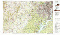
~ Washington West DC topo map, 1:100000 scale, 30 X 60 Minute, Historical, 1986, updated 1986
Washington West, District of Columbia, USGS topographic map dated 1986.
Includes geographic coordinates (latitude and longitude). This topographic map is suitable for hiking, camping, and exploring, or framing it as a wall map.
Printed on-demand using high resolution imagery, on heavy weight and acid free paper, or alternatively on a variety of synthetic materials.
Topos available on paper, Waterproof, Poly, or Tyvek. Usually shipping rolled, unless combined with other folded maps in one order.
- Product Number: USGS-5389854
- Free digital map download (high-resolution, GeoPDF): Washington West, District of Columbia (file size: 37 MB)
- Map Size: please refer to the dimensions of the GeoPDF map above
- Weight (paper map): ca. 55 grams
- Map Type: POD USGS Topographic Map
- Map Series: HTMC
- Map Verison: Historical
- Cell ID: 76846
- Scan ID: 255913
- Imprint Year: 1986
- Woodland Tint: Yes
- Visual Version Number: 1
- Aerial Photo Year: 1984
- Edit Year: 1986
- Datum: NAD27
- Map Projection: Universal Transverse Mercator
- Map published by United States Geological Survey
- Map Language: English
- Scanner Resolution: 600 dpi
- Map Cell Name: Washington West
- Grid size: 30 X 60 Minute
- Date on map: 1986
- Map Scale: 1:100000
- Geographical region: District of Columbia, United States
Neighboring Maps:
All neighboring USGS topo maps are available for sale online at a variety of scales.
Spatial coverage:
Topo map Washington West, District of Columbia, covers the geographical area associated the following places:
- Chinquapin Village - Westgate - Friendship Heights - Adams Morgan - Manassas Park - Mandleys Corner - Springfield Estates - Crowells Corner - Wakefield Forest - Sudley Mountain Estates - Tysons Green - Ravensworth - Kings Crossroads - Elm Farm Mobile Home Park - Bannockburn - New Hope - Port Tobacco Riviera - Tulip Hill - Virginia Highlands - Greenwich Forest - Woodlawn - Westwood - Mountainview - Jefferson - Woodbine Woods - Woodburn - Senate Heights - Glencarlyn - Arlington Village - Shaw - Fair Vernon - Lakeview - Sulgrave Manor - Rectortown - Orlean - Airlie - LeDroit Park - Clarendon - Orangedale - Silver Spring Park - Clover Hill - Country Club View - Carolandville - Fairview - Meadowbrook - North Takoma Park - Boulevard Estates - Fair Haven - Kalorama Triangle - Indian Head - Orchard Bridge - Rison Acres - North Cleveland Park - River Ridge Estates - Fort Ward Heights - Burleith - Yorkshire Acres - Makleys Corner - Rosemary Hills - Avon Crest - Lenah - Columbia Park - Chevy Chase Lake - Old Mill Estates - Old Conde - Knollwood Estates - South Fairlington - Cinnamon Creek - Keene Mill Heights - Freedom Village - Robie Manor - Breezy Knolls Estates - Marumsco Village - Woodmont - Edsall Park - River Bend Estates - Beau Ridge - Upperville - Groveton Heights - Hawthorne - Brookville - Youngsborough (historical) - Parkview Hills - Falls Church - Indian Head Manor - Park View - The Palisades - Columbia Forest - Odricks Corner - Broad Run Village - Ridgedale - Montclair - Crescent - Riverview Estates - Colchester Acres - Fort Washington Estates - Franconia - Masonville - Cedar Crest - Kennard Ridge
- Map Area ID: AREA3938.5-78-77
- Northwest corner Lat/Long code: USGSNW39-78
- Northeast corner Lat/Long code: USGSNE39-77
- Southwest corner Lat/Long code: USGSSW38.5-78
- Southeast corner Lat/Long code: USGSSE38.5-77
- Northern map edge Latitude: 39
- Southern map edge Latitude: 38.5
- Western map edge Longitude: -78
- Eastern map edge Longitude: -77