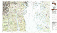
~ Washington East DC topo map, 1:100000 scale, 30 X 60 Minute, Historical, 1983, updated 1992
Washington East, District of Columbia, USGS topographic map dated 1983.
Includes geographic coordinates (latitude and longitude). This topographic map is suitable for hiking, camping, and exploring, or framing it as a wall map.
Printed on-demand using high resolution imagery, on heavy weight and acid free paper, or alternatively on a variety of synthetic materials.
Topos available on paper, Waterproof, Poly, or Tyvek. Usually shipping rolled, unless combined with other folded maps in one order.
- Product Number: USGS-5389850
- Free digital map download (high-resolution, GeoPDF): Washington East, District of Columbia (file size: 28 MB)
- Map Size: please refer to the dimensions of the GeoPDF map above
- Weight (paper map): ca. 55 grams
- Map Type: POD USGS Topographic Map
- Map Series: HTMC
- Map Verison: Historical
- Cell ID: 68549
- Scan ID: 255911
- Imprint Year: 1992
- Woodland Tint: Yes
- Aerial Photo Year: 1981
- Edit Year: 1983
- Datum: NAD27
- Map Projection: Universal Transverse Mercator
- Map published by United States Geological Survey
- Map Language: English
- Scanner Resolution: 600 dpi
- Map Cell Name: Washington East
- Grid size: 30 X 60 Minute
- Date on map: 1983
- Map Scale: 1:100000
- Geographical region: District of Columbia, United States
Neighboring Maps:
All neighboring USGS topo maps are available for sale online at a variety of scales.
Spatial coverage:
Topo map Washington East, District of Columbia, covers the geographical area associated the following places:
- River Club Estates - Anchorage Park Mobile Home Park - Arrowhead Farms Estates - Walnut Shores - Croom - North Glenwood - Burch - Gatts Corner - Eatons Landing - Swan Villas - New Hampshire Gardens - Old Fort Acres - Ardmore - Silver Hill Park - Portland Manor - Riva - Gilnock Hall - West Beach - Old Cedar Point - Parrans Woods - Turnbull Estates - Brookwood Estates - Kirkwood - Smithbrooke - Kent Island Estates - Green Acres Estates - Forest Villa - Brookwood Acres - Sylvan Shores - Woodland - Oak Court - Ivytown - Hyattsville Hills - South Haven - Overbrook - Holly Hill - Holly Hill Harbor - Windward Key - Tanglewood - Terre Verde - Mariners Cove - Traceys Meadows - Mill Branch Estates - Colebrooke - Steuart Level - Waysons Corner - Cape Anne - Jacktown - Holly Oaks - Cedar Lawn - Chaneyville Farm Estates - Dorsey Heights - Cedarhaven - Mallard Point - Poplar Woods - Queenstown - Hall - Mariners Point - Naylor - Huntingtown - Queen Anne Colony - Baldwin Acres - Nacocktanke (historical) - Forest Glen Estates - Grasonville - Heather Knolls - Tilghman Island Beach - Bryantown Hills - Bay Country - Hughesville - Locust Grove - Wilson (historical) - Bayard - Lowery Oaks - Accokeek Acres - Newtown Square - Crabapple Court - Stanton Park - Valliant - Bywater Estates - Grosstown - Brentwood Village - Clinton Acres - Fort Dupont - Brightseat - Oxford - Starr - Woodside View - Bozman - Cedar Point - Calvert Estates - Wrights - Pond View Acres - Brightwood - Old Villa - Eickelberry Woods - Ashbox - Autumn Estates - Pleasant Springs - Tates Bank
- Map Area ID: AREA3938.5-77-76
- Northwest corner Lat/Long code: USGSNW39-77
- Northeast corner Lat/Long code: USGSNE39-76
- Southwest corner Lat/Long code: USGSSW38.5-77
- Southeast corner Lat/Long code: USGSSE38.5-76
- Northern map edge Latitude: 39
- Southern map edge Latitude: 38.5
- Western map edge Longitude: -77
- Eastern map edge Longitude: -76