
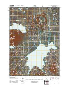
~ Crane Prairie Reservoir OR topo map, 1:24000 scale, 7.5 X 7.5 Minute, Historical, 2011
Crane Prairie Reservoir, Oregon, USGS topographic map dated 2011.
Includes geographic coordinates (latitude and longitude). This topographic map is suitable for hiking, camping, and exploring, or framing it as a wall map.
Printed on-demand using high resolution imagery, on heavy weight and acid free paper, or alternatively on a variety of synthetic materials.
Topos available on paper, Waterproof, Poly, or Tyvek. Usually shipping rolled, unless combined with other folded maps in one order.
- Product Number: USGS-5389556
- Free digital map download (high-resolution, GeoPDF): Crane Prairie Reservoir, Oregon (file size: 25 MB)
- Map Size: please refer to the dimensions of the GeoPDF map above
- Weight (paper map): ca. 55 grams
- Map Type: POD USGS Topographic Map
- Map Series: US Topo
- Map Verison: Historical
- Cell ID: 10589
- Datum: North American Datum of 1983
- Map Projection: Transverse Mercator
- Map Cell Name: Crane Prairie Reservoir
- Grid size: 7.5 X 7.5 Minute
- Date on map: 2011
- Map Scale: 1:24000
- Geographical region: Oregon, United States
Neighboring Maps:
All neighboring USGS topo maps are available for sale online at a variety of scales.
Spatial coverage:
Topo map Crane Prairie Reservoir, Oregon, covers the geographical area associated the following places:
- Deschutes Bridge Recreation Site - Quinn River Boat Ramp - Cow Meadow Boat Ramp - North Corral Lake - Cultus Corral Horse Camp - Cultus Mountain - Ketchketch Butte - Robideau Landing - Twins Crane Prairie Trail - Deer Creek - Craine Prairie Campground Boat Ramp - Rock Creek Recreation Site - Corral Swamp - Cultus Lake Recreation Site - Snow Creek Project Camp - Corral Swamp Trail - Little Cultus Lake Campground Boat Ramp - West Cultus Lake Recreation Site - Gales Landing - Crane Prairie Dam - Rock Creek Campground Boat Ramp - Wuksi Butte - Palanush Butte - Crane Prairie - Craine Prairie Resort Marina - Snow Creek - Quinn River Recreation Site - Billy Quinn Grave - Little Cultus Lake Recreation Site - Craine Prairie Reservoir Day Use Boat Ramp - Cultus Cove Recreation Site - Cow Meadow Recreation Site - Cultus Lake Resort - Comma Lake - Bench Mark Butte - Shukash Butte - Hidden Spring - Little Cultus Lake - Osprey Point Recreation Site - Cultus Lake - South Corral Lake - Crane Prairie Resort - Cultus Lake Boat Ramp - Osprey Point - Cultus Lake Trail - Charlton Creek - Cultus River - Crane Prairie Recreation Site - Cultus Creek - Crane Prairie Reservoir - Deschutes Bridge Guard Station (historical) - Browns Mountain Boat Ramp - Cultus Lake Resort Marina - Multiple Springs
- Map Area ID: AREA43.87543.75-121.875-121.75
- Northwest corner Lat/Long code: USGSNW43.875-121.875
- Northeast corner Lat/Long code: USGSNE43.875-121.75
- Southwest corner Lat/Long code: USGSSW43.75-121.875
- Southeast corner Lat/Long code: USGSSE43.75-121.75
- Northern map edge Latitude: 43.875
- Southern map edge Latitude: 43.75
- Western map edge Longitude: -121.875
- Eastern map edge Longitude: -121.75


