
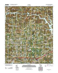
~ Valley Falls SC topo map, 1:24000 scale, 7.5 X 7.5 Minute, Historical, 2011
Valley Falls, South Carolina, USGS topographic map dated 2011.
Includes geographic coordinates (latitude and longitude). This topographic map is suitable for hiking, camping, and exploring, or framing it as a wall map.
Printed on-demand using high resolution imagery, on heavy weight and acid free paper, or alternatively on a variety of synthetic materials.
Topos available on paper, Waterproof, Poly, or Tyvek. Usually shipping rolled, unless combined with other folded maps in one order.
- Product Number: USGS-5389430
- Free digital map download (high-resolution, GeoPDF): Valley Falls, South Carolina (file size: 23 MB)
- Map Size: please refer to the dimensions of the GeoPDF map above
- Weight (paper map): ca. 55 grams
- Map Type: POD USGS Topographic Map
- Map Series: US Topo
- Map Verison: Historical
- Cell ID: 46565
- Datum: North American Datum of 1983
- Map Projection: Transverse Mercator
- Map Cell Name: Valley Falls
- Grid size: 7.5 X 7.5 Minute
- Date on map: 2011
- Map Scale: 1:24000
- Geographical region: South Carolina, United States
Neighboring Maps:
All neighboring USGS topo maps are available for sale online at a variety of scales.
Spatial coverage:
Topo map Valley Falls, South Carolina, covers the geographical area associated the following places:
- Sunnydale Acres - Lakeview Manor - Quail Ridge - Rainbow Park - Clearview Heights - Northwood - Meadow Spring - Shoally Creek - Spring Hills - Sherman Park - Valley Falls - Fosters Grove - North Hills - Kentwood - Northgate - Peach Valley Fairway Estates - Beverly Woods - Boiling Springs - Twin Creek - Ferndale - Diamond J Mobile Home Park - Panorama Estates - Carlisle - Cherokee Springs - Thunderbird Mobile Home Park - McGreegor Downs - Peachtree Gardens - Mason Estates - Northbrook Park - Springlake - Canterbury Heights - Laurelwood - Pinebrook Mobile Home Community - Woodcreek - North Hill Acres - Luray Hills - Lynwood - Mountain View - Thorn Ridge Mobile Home Park - Mountainbrook - Midland Estates
- Map Area ID: AREA35.12535-82-81.875
- Northwest corner Lat/Long code: USGSNW35.125-82
- Northeast corner Lat/Long code: USGSNE35.125-81.875
- Southwest corner Lat/Long code: USGSSW35-82
- Southeast corner Lat/Long code: USGSSE35-81.875
- Northern map edge Latitude: 35.125
- Southern map edge Latitude: 35
- Western map edge Longitude: -82
- Eastern map edge Longitude: -81.875


