
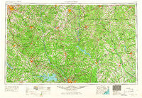
~ Spartanburg SC topo map, 1:250000 scale, 1 X 2 Degree, Historical, 1953, updated 1966
Spartanburg, South Carolina, USGS topographic map dated 1953.
Includes geographic coordinates (latitude and longitude). This topographic map is suitable for hiking, camping, and exploring, or framing it as a wall map.
Printed on-demand using high resolution imagery, on heavy weight and acid free paper, or alternatively on a variety of synthetic materials.
Topos available on paper, Waterproof, Poly, or Tyvek. Usually shipping rolled, unless combined with other folded maps in one order.
- Product Number: USGS-5389168
- Free digital map download (high-resolution, GeoPDF): Spartanburg, South Carolina (file size: 21 MB)
- Map Size: please refer to the dimensions of the GeoPDF map above
- Weight (paper map): ca. 55 grams
- Map Type: POD USGS Topographic Map
- Map Series: HTMC
- Map Verison: Historical
- Cell ID: 74963
- Scan ID: 262055
- Imprint Year: 1966
- Woodland Tint: Yes
- Edit Year: 1965
- Field Check Year: 1953
- Datum: Unstated
- Map Projection: Transverse Mercator
- Map published by United States Geological Survey
- Map published by United States Army Corps of Engineers
- Map published by United States Army
- Map Language: English
- Scanner Resolution: 600 dpi
- Map Cell Name: Spartanburg
- Grid size: 1 X 2 Degree
- Date on map: 1953
- Map Scale: 1:250000
- Geographical region: South Carolina, United States
Neighboring Maps:
All neighboring USGS topo maps are available for sale online at a variety of scales.
Spatial coverage:
Topo map Spartanburg, South Carolina, covers the geographical area associated the following places:
- Riverside - Arrowood Estates - Chimney Ridge - Hillcrest - Frost - Rich Hill Crossroads - Mechanicsville - Lake Point - Hillsville - Pisgah - Friendship - Hidden Hills - Aman (historical) - Golightly - Cinder Creek - Johnson City - Allen Acres - Leaphart - Cassatt - Richland - White Rock - Oakwood Acres - Elgin Acres - Andrews Farms - Delta - Russellville - Woodburn Hills - Zemp - Waverly - Rock Rest - Charleswood - Green Hill - Zion Hill - Pine Creek - Marvin - Hornsboro - Cambridge - Stomp Springs - Longtown - Greenfield Acres - Hampton Trace - Dinber - White Oak - Kalmia Place - Newport - Roebuck - Evergreen Acres - Walton (historical) - English (historical) - Willow Acres - Lake Forest - Southeast Newberry - Bentway Park - Westover Acres - Una - Huntington Hills - Baker Place - Green Valley Estates - Airlee - Blue Spring (historical) - Springdale - Town and Country Estates - Anglewood - McLaughlin Crossroads - Byrneswood - Boyden Arbor - Converse - Peters - Red River - Gettysburg - Whitney Heights - Big Springs - Drayton - Huntcliff - Brockington Heights - Big Creek - Pomaria - Jalapa - Cedar Creek - Flint Hill - Gould (historical) - Paint Hill - Saint Charles - Calvin (historical) - Forestwood Estates - Wildcat (historical) - Flat Rock - Dutch Square - Godgold Subdivision - Wilkes Crossroads - Union - Sheffield - Deep Creek - Catchall - Richburg - Quail Hollow - Anglers Haven - Elgin - Mineral Springs - Lebanon
- Map Area ID: AREA3534-82-80
- Northwest corner Lat/Long code: USGSNW35-82
- Northeast corner Lat/Long code: USGSNE35-80
- Southwest corner Lat/Long code: USGSSW34-82
- Southeast corner Lat/Long code: USGSSE34-80
- Northern map edge Latitude: 35
- Southern map edge Latitude: 34
- Western map edge Longitude: -82
- Eastern map edge Longitude: -80


