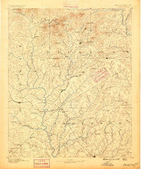
~ Pickens SC topo map, 1:125000 scale, 30 X 30 Minute, Historical, 1888
Pickens, South Carolina, USGS topographic map dated 1888.
Includes geographic coordinates (latitude and longitude). This topographic map is suitable for hiking, camping, and exploring, or framing it as a wall map.
Printed on-demand using high resolution imagery, on heavy weight and acid free paper, or alternatively on a variety of synthetic materials.
Topos available on paper, Waterproof, Poly, or Tyvek. Usually shipping rolled, unless combined with other folded maps in one order.
- Product Number: USGS-5389118
- Free digital map download (high-resolution, GeoPDF): Pickens, South Carolina (file size: 7 MB)
- Map Size: please refer to the dimensions of the GeoPDF map above
- Weight (paper map): ca. 55 grams
- Map Type: POD USGS Topographic Map
- Map Series: HTMC
- Map Verison: Historical
- Cell ID: 66326
- Scan ID: 262028
- Survey Year: 1886
- Datum: Unstated
- Map Projection: Unstated
- Map published by United States Geological Survey
- Map Language: English
- Scanner Resolution: 600 dpi
- Map Cell Name: Pickens
- Grid size: 30 X 30 Minute
- Date on map: 1888
- Map Scale: 1:125000
- Geographical region: South Carolina, United States
Neighboring Maps:
All neighboring USGS topo maps are available for sale online at a variety of scales.
Spatial coverage:
Topo map Pickens, South Carolina, covers the geographical area associated the following places:
- Kings Court - Beaver Creek - Vista Grove - Springbrook - Southern Meadows - Vista Heights - Oconee Point - Pickens - Oakwood Estates - Harbin Acres - Monte Vista - Snug Harbor - Royal Acres - Jocassee - Woodfarm Acres - Keystone Acres - Green Forest - Burdine Springs - Fairfield Acres - Marilyn Acres - Long Meadows - Smithfields - George Martin Acres - Hanover Hills - Newry - Spring Park - White Harbor - Sugar Hill - Bishop Heights - Crow Creek - Shadow Wood - Douthit Hills - Fieldcrest Acres - Poplar Cove - Cardinal Park - Timberlane - Hampton Acres - Leisure Village - Briarcliff - McGee Acres - Ole Salem Estates - Twin Lakes - Homestead Estates - Knoxwood - Holly Creek - Windsor Place - Gilstrap - Pleasant View - Longcreek - Campbell - Heritage Hills - Piercetown - Springdale - Anderson Village - Pearidge - Hamilton Heights - Englewood - Nine Times - Gilmer Estates - Shiloh - Hendricks - Woodbridge - Dellwood - Five Forks - Lakeview Heights - Utica - Five Forks - Carolina Hills - Huntington Hills - Valley View - Forest Park - Salem - Tokeena Point - Brookwood - Denver - Botany Park - Stone Haven - Dalton - Hunters Trail - Oxford - Quail Creek - Keowee - Nimmons - Carter Hall - Cherrys Crossing - Rosewood Heights - Countryside Manor - Anderson - Cambridge Place - Ashley Downs - Canaan Land - Doris Heights - Earles Grove - Quail Hollow - Huntington North - Waverly Square - Stratford Terrace - Indian Oaks - Concord - Townville
- Map Area ID: AREA3534.5-83-82.5
- Northwest corner Lat/Long code: USGSNW35-83
- Northeast corner Lat/Long code: USGSNE35-82.5
- Southwest corner Lat/Long code: USGSSW34.5-83
- Southeast corner Lat/Long code: USGSSE34.5-82.5
- Northern map edge Latitude: 35
- Southern map edge Latitude: 34.5
- Western map edge Longitude: -83
- Eastern map edge Longitude: -82.5

