
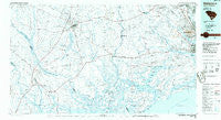
~ Walterboro SC topo map, 1:100000 scale, 30 X 60 Minute, Historical, 1986, updated 1986
Walterboro, South Carolina, USGS topographic map dated 1986.
Includes geographic coordinates (latitude and longitude). This topographic map is suitable for hiking, camping, and exploring, or framing it as a wall map.
Printed on-demand using high resolution imagery, on heavy weight and acid free paper, or alternatively on a variety of synthetic materials.
Topos available on paper, Waterproof, Poly, or Tyvek. Usually shipping rolled, unless combined with other folded maps in one order.
- Product Number: USGS-5389102
- Free digital map download (high-resolution, GeoPDF): Walterboro, South Carolina (file size: 21 MB)
- Map Size: please refer to the dimensions of the GeoPDF map above
- Weight (paper map): ca. 55 grams
- Map Type: POD USGS Topographic Map
- Map Series: HTMC
- Map Verison: Historical
- Cell ID: 68546
- Scan ID: 262021
- Imprint Year: 1986
- Aerial Photo Year: 1984
- Edit Year: 1986
- Datum: NAD27
- Map Projection: Universal Transverse Mercator
- Planimetric: Yes
- Map published by United States Geological Survey
- Map Language: English
- Scanner Resolution: 600 dpi
- Map Cell Name: Walterboro
- Grid size: 30 X 60 Minute
- Date on map: 1986
- Map Scale: 1:100000
- Geographical region: South Carolina, United States
Neighboring Maps:
All neighboring USGS topo maps are available for sale online at a variety of scales.
Spatial coverage:
Topo map Walterboro, South Carolina, covers the geographical area associated the following places:
- Ashley Acres - Pleasant Hills - Shadowmoss - Dupont Station - Seabrook Island - Flowertown Village - Ashley Heights - Greenwood Park - Castlewood - Pepperhill - Essex Village - Rose Hill - Hollywood - Wilsonville - The Oaks - Singing Pines - Liberty Hills - Kings Grant - Willowbrook - Harbour Lake - Goshen - Stokes - Gettysville - Chandler Village - Highlands - Rockville - Barkerville - Ararat - Canaan - Lobeco - Sniders Crossroads - Davidson - Orleans Estates - Coosaw - Drigger Crossroads - Winwright (historical) - Gannon (historical) - Rockland - Dorchester Estates - Ashley Harbor - Hickory Hill - Possum Corner - Tranquil Estates - Orleans Woods - Pinewood Vista - Chandler Lakes - Colony North - Fairlawn Terrace - Wood Oak Park - Knowles - Laroche - Greggs Landing - Pinecrest - Radnor (historical) - Freedman - Ricetown - Drayton - Cummings - Sedgefield - Wiggins - Bells Crossroads - University Park - Stallsville - Maple Ridge - Berry Hill - Tenmile - Coventry Place - Laurel Hill - Burr Hill - Padgett Landing - Tobys Bluff - Dorchester Manor - White Point Landing - Waters Edge - Barney Ridge - Miller Hill - Ferndale - Camelot Village - Willtown Bluff - Davis Hill - Gloverville - Rhodes Crossroads - Hiotts - Church Creek - Laurel Hill - Oakdale Estates - Briarwood - Jacksonboro - McPhersonville - Murry Hill - Red Top - Huskum Corner Cross Roads - Burnt Church Crossroads - Sylvia Lane - Yonges Island - Barrelville - Indigo Point - Kelsey Cove Landing - Gardens Corner - Southern Palms
- Map Area ID: AREA3332.5-81-80
- Northwest corner Lat/Long code: USGSNW33-81
- Northeast corner Lat/Long code: USGSNE33-80
- Southwest corner Lat/Long code: USGSSW32.5-81
- Southeast corner Lat/Long code: USGSSE32.5-80
- Northern map edge Latitude: 33
- Southern map edge Latitude: 32.5
- Western map edge Longitude: -81
- Eastern map edge Longitude: -80


