
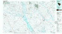
~ Sumter SC topo map, 1:100000 scale, 30 X 60 Minute, Historical, 1986, updated 1986
Sumter, South Carolina, USGS topographic map dated 1986.
Includes geographic coordinates (latitude and longitude). This topographic map is suitable for hiking, camping, and exploring, or framing it as a wall map.
Printed on-demand using high resolution imagery, on heavy weight and acid free paper, or alternatively on a variety of synthetic materials.
Topos available on paper, Waterproof, Poly, or Tyvek. Usually shipping rolled, unless combined with other folded maps in one order.
- Product Number: USGS-5389098
- Free digital map download (high-resolution, GeoPDF): Sumter, South Carolina (file size: 21 MB)
- Map Size: please refer to the dimensions of the GeoPDF map above
- Weight (paper map): ca. 55 grams
- Map Type: POD USGS Topographic Map
- Map Series: HTMC
- Map Verison: Historical
- Cell ID: 68424
- Scan ID: 262019
- Imprint Year: 1986
- Aerial Photo Year: 1983
- Edit Year: 1986
- Datum: NAD27
- Map Projection: Universal Transverse Mercator
- Planimetric: Yes
- Map published by United States Geological Survey
- Map Language: English
- Scanner Resolution: 600 dpi
- Map Cell Name: Sumter
- Grid size: 30 X 60 Minute
- Date on map: 1986
- Map Scale: 1:100000
- Geographical region: South Carolina, United States
Neighboring Maps:
All neighboring USGS topo maps are available for sale online at a variety of scales.
Spatial coverage:
Topo map Sumter, South Carolina, covers the geographical area associated the following places:
- Hilldale - Mayesville - Deer Ridge Farms - Warwick Estates - Marshall Heights - Pinehurst - Quail Hills - Paxville - Bay Springs - Southgate - San Marco Estates - Seloc - Carolina Gardens - Dominion Hills - Claremont - Hillview - Summerton - Wedgewood - Parlerdale - Conover Hill - Panola - Forest Hills - Shad Moss village - Flowers Heights - Pine Acres - West Ridge - Heatherwood - Ranchland Ranchettes - New Zion - Pleasant Grove - Sheridan Estates - Briarcliff Estates - Privateer - Mountain Brook - Summer View - Rimini - North Deerfield - Hyde Park - Independents - Foreston - Fulton Crossroads - Hopkins - Whites Pond Crossroad - Folsom Park - Wren Village - Cartley Subdivision - Bruner - Edgewater - Windsor City Mobile Home Park - Bonanza (historical) - Galaxy - Sellars Heights - Harvin - Knollwood - Log Jam Landing - Hampton Ridge - Moss Hills - Burns Down - South Sumter - Dalby Downs - Robin Hill Farm - Country Club Estates - Gerwil Acres - Huntington - Ivey Hall - Eastmont - Midfield - Iris Heights - Midland Acres - Green Acres - White Oak - Saint Paul - Hunter Hill - Plantation Subdivision - Bendemeer - Dixie Circle - Trinity Cross Roads - Shiloh - Malta - Greenbriar - General Sumter Estates - Greenfield - Brogdon - Harvins Crossroads - Stokes - Frierson - Pine Tops - Brady Heights - Sherwood Forest - Riley - Dinkins - Belser Crossroads - Pine Lake - Scottsville - Berkeley Forest - Meadowfield - East Sumter - Bonneville - Gable - Millwood
- Map Area ID: AREA3433.5-81-80
- Northwest corner Lat/Long code: USGSNW34-81
- Northeast corner Lat/Long code: USGSNE34-80
- Southwest corner Lat/Long code: USGSSW33.5-81
- Southeast corner Lat/Long code: USGSSE33.5-80
- Northern map edge Latitude: 34
- Southern map edge Latitude: 33.5
- Western map edge Longitude: -81
- Eastern map edge Longitude: -80


