
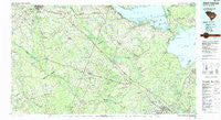
~ Saint George SC topo map, 1:100000 scale, 30 X 60 Minute, Historical, 1990, updated 1990
Saint George, South Carolina, USGS topographic map dated 1990.
Includes geographic coordinates (latitude and longitude). This topographic map is suitable for hiking, camping, and exploring, or framing it as a wall map.
Printed on-demand using high resolution imagery, on heavy weight and acid free paper, or alternatively on a variety of synthetic materials.
Topos available on paper, Waterproof, Poly, or Tyvek. Usually shipping rolled, unless combined with other folded maps in one order.
- Product Number: USGS-5389092
- Free digital map download (high-resolution, GeoPDF): Saint George, South Carolina (file size: 25 MB)
- Map Size: please refer to the dimensions of the GeoPDF map above
- Weight (paper map): ca. 55 grams
- Map Type: POD USGS Topographic Map
- Map Series: HTMC
- Map Verison: Historical
- Cell ID: 68280
- Scan ID: 262016
- Imprint Year: 1990
- Woodland Tint: Yes
- Aerial Photo Year: 1987
- Edit Year: 1990
- Datum: NAD27
- Map Projection: Universal Transverse Mercator
- Map published by United States Geological Survey
- Map Language: English
- Scanner Resolution: 600 dpi
- Map Cell Name: Saint George
- Grid size: 30 X 60 Minute
- Date on map: 1990
- Map Scale: 1:100000
- Geographical region: South Carolina, United States
Neighboring Maps:
All neighboring USGS topo maps are available for sale online at a variety of scales.
Spatial coverage:
Topo map Saint George, South Carolina, covers the geographical area associated the following places:
- Saint Julian - Whittaker Estates - Saint George - Beverly Hills - Pigeon Bay (historical) - Edisto - Strawberry - Fairfax - Garbon Subdivision - Providence - New Hope - Springtown - Pinehill - Pine View - Sandy Run (historical) - Old Saint George - Beverly Hills - Sawmill Terrace - Mill Creek - Lambrick - Williams Plaza - Windwood - Santee - Wampee - Twin Lakes - Bowyer - Padgetts - Whetsell - Orangeburg Manor - Vance - Warington - Harleyville - Ferguson (historical) - Gadsden Place - Forest Acres - Grover - Shephard Park - Boulder Bluff - Hussertown - Wassamassaw (historical) - Highland Park - Church Hill (historical) - Cross - Embree - Inabinetts (historical) - Summerset Acres - Casey Hill (historical) - Tea Farm - Midway - Cotton Hill - Flowertown Estates - Cross Cross Roads - Corsada (historical) - Spring Hill - Badham - Tuckertown - Rosinville - Williams - Oak Park - Pineforest Inn - Hope (historical) - Moncks Corner - Ferguson Landing - Mudville (historical) - Berkeley Country Club Subdivision - Orangewood - Meadowbrook - Oak Hill - Cow Tail (historical) - Eutawville - Rowesville - Mount Pisgah - Carnes Crossroad - North Brentwood - Givhans - Sangaree - Felderville - Oakatee - Haddock - Moorefield - Byrd - Long Ridge - Saint Johns - Lotts Crossroads - Orchard Hill - Green Hill (historical) - Connors (historical) - Bombaretta (historical) - Pineville - Riverdale - Seaton - Tall PInes - Rosehill - Heritage Subdivision - Colonial Heights - Fifty Eight (historical) - The Barrows - Eutaw Springs - Jedburg - Cloverleaf Mobile Home Park
- Map Area ID: AREA33.533-81-80
- Northwest corner Lat/Long code: USGSNW33.5-81
- Northeast corner Lat/Long code: USGSNE33.5-80
- Southwest corner Lat/Long code: USGSSW33-81
- Southeast corner Lat/Long code: USGSSE33-80
- Northern map edge Latitude: 33.5
- Southern map edge Latitude: 33
- Western map edge Longitude: -81
- Eastern map edge Longitude: -80


