
~ Camden South SC topo map, 1:100000 scale, 30 X 60 Minute, Historical, 1986, updated 1990
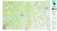
Camden South, South Carolina, USGS topographic map dated 1986.
Includes geographic coordinates (latitude and longitude). This topographic map is suitable for hiking, camping, and exploring, or framing it as a wall map.
Printed on-demand using high resolution imagery, on heavy weight and acid free paper, or alternatively on a variety of synthetic materials.
Topos available on paper, Waterproof, Poly, or Tyvek. Usually shipping rolled, unless combined with other folded maps in one order.
- Product Number: USGS-5389058
- Free digital map download (high-resolution, GeoPDF): Camden South, South Carolina (file size: 30 MB)
- Map Size: please refer to the dimensions of the GeoPDF map above
- Weight (paper map): ca. 55 grams
- Map Type: POD USGS Topographic Map
- Map Series: HTMC
- Map Verison: Historical
- Cell ID: 67215
- Scan ID: 261999
- Imprint Year: 1990
- Woodland Tint: Yes
- Aerial Photo Year: 1934
- Edit Year: 1986
- Datum: NAD27
- Map Projection: Universal Transverse Mercator
- Map published by United States Geological Survey
- Map Language: English
- Scanner Resolution: 600 dpi
- Map Cell Name: Camden
- Grid size: 30 X 60 Minute
- Date on map: 1986
- Map Scale: 1:100000
- Geographical region: South Carolina, United States
Neighboring Maps:
All neighboring USGS topo maps are available for sale online at a variety of scales.
Spatial coverage:
Topo map Camden South, South Carolina, covers the geographical area associated the following places:
- Pine Land - Valley Park - Una - Bethune - Lakefield Circle - Kirkley Mill - Sandwood - Lamar - East Lake Hills - Pecan Acres - Springhill - Sandwood Hills - Forest Trace - Kirkland - Oswego - Rock Branch North - Oats - Edgewood - Dekalb - Gregg Park - Blaney West - Ridgeway - Boney - Blythewood - Woodrow - Lees Crossroads - Blaney Hills - Wilkes Crossroads - Blue Spring (historical) - Drexel Lake Hills - Kingsville Heights - Richland - Hammetts Crossroads - Meadow View - Green Hill - Yarborough Crossroads - Flint Hill - McCutchen (historical) - Leesburg - Rosa Lees Crossroads - Bellfield (historical) - Burrows Crossroads - Briarwood - Hillcrest - Woodfield - Deaswood - Spring Valley - North Springs - Godgold Subdivision - Woodland Forest - Tanglewood - Lake Elizabeth Estates - Pine Mark - Bee Tree (historical) - McLaughlin Crossroads - White Gardens - Forest Hills - South Lynchburg - Cantys Lane - English (historical) - Manville - Tabernacle (historical) - Vaughans Crossroads - State Farm (historical) - Hagood - Satchel Ford Terrace - Branham Heights - Cedar Creek - Windsor Lake Park - Lakewood - Aman (historical) - Sunnyhill - West Hartsville - Hartsville - Deloach (historical) - Gaillard Crossroads - Forest Acres - Smallwood - Hillcrest - Spring Lake - Tillersville - Kilbourne Heights - College Heights - Jeffers Place - Leland - Cypress Crossroads - Elgin Acres - McCoys Crossroads - Happy Home Subdivision - Grannys Quarter (historical) - McBee - Fairfax - North Washington Park - Spring Village - North Pines - Sanders Corner - Botany Woods - Pontiac - McCaskill - Dentsville
- Map Area ID: AREA34.534-81-80
- Northwest corner Lat/Long code: USGSNW34.5-81
- Northeast corner Lat/Long code: USGSNE34.5-80
- Southwest corner Lat/Long code: USGSSW34-81
- Southeast corner Lat/Long code: USGSSE34-80
- Northern map edge Latitude: 34.5
- Southern map edge Latitude: 34
- Western map edge Longitude: -81
- Eastern map edge Longitude: -80


