
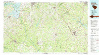
~ Abbeville SC topo map, 1:100000 scale, 30 X 60 Minute, Historical, 1979, updated 1980
Abbeville, South Carolina, USGS topographic map dated 1979.
Includes geographic coordinates (latitude and longitude). This topographic map is suitable for hiking, camping, and exploring, or framing it as a wall map.
Printed on-demand using high resolution imagery, on heavy weight and acid free paper, or alternatively on a variety of synthetic materials.
Topos available on paper, Waterproof, Poly, or Tyvek. Usually shipping rolled, unless combined with other folded maps in one order.
- Product Number: USGS-5389044
- Free digital map download (high-resolution, GeoPDF): Abbeville, South Carolina (file size: 30 MB)
- Map Size: please refer to the dimensions of the GeoPDF map above
- Weight (paper map): ca. 55 grams
- Map Type: POD USGS Topographic Map
- Map Series: HTMC
- Map Verison: Historical
- Cell ID: 67007
- Scan ID: 261992
- Imprint Year: 1980
- Woodland Tint: Yes
- Visual Version Number: 2
- Aerial Photo Year: 1974
- Edit Year: 1979
- Datum: NAD27
- Map Projection: Universal Transverse Mercator
- Map published by United States Geological Survey
- Map Language: English
- Scanner Resolution: 600 dpi
- Map Cell Name: Abbeville
- Grid size: 30 X 60 Minute
- Date on map: 1979
- Map Scale: 1:100000
- Geographical region: South Carolina, United States
Neighboring Maps:
All neighboring USGS topo maps are available for sale online at a variety of scales.
Spatial coverage:
Topo map Abbeville, South Carolina, covers the geographical area associated the following places:
- Dann (historical) - Dosheno - Blue Heaven - Augusta Fields - Clatworthy Crossroads - Barnes Station - Holland Store - Diamond Hill Spring (historical) - Hyde Park - Country Homes - Parkwood - Arborville - Bradley - Honea Path - Millers Mill - Pearl - Whitehall - Broadmouth - Montevideo - The Hook (historical) - Simpson (historical) - Lake Secession - Vandale Place - Downs Siding - Calhoun Falls - Springdale - Forest Hills - Clover Hill - Carolina Springs - Sunset Acres - Nevitt Pines - Ware Shoals - Pine Grove Hills - Rock Creek - Centerville - Normandy Park Junior - Fairs Crossroads - Grendel Village - Bullock (historical) - Iva - Charleston Crossroads - Maddens - North Elberton - Dover (historical) - Smithville (historical) - Wade Heights - Salak - Cedar Lake - Belcher Crossroads - Reed Creek - Aix (historical) - Gluck - Beechwood - Foxville Crossroads - Andersonville (historical) - Avondale - Warrenton - Mathews Heights - Westgate - Lakewood Heights - Saylors Crossroads - Idlewood - Kirksey - Forest Lake - Deans - Blakedale - Amandaville (historical) - Kimbrook - Maretts - Baldwin - Meadow Fields - Fawn Brook - Tinsley - Brownlee Crossroads - Anderson Gardens - Hammett (historical) - Westview Heights - Ninety Six - New Market - Ellenwood Acres - Keowee - West View - Lota - Druid Hills - Irby - Sadler (historical) - Lake Shores - Moffitsville - Cherokee Hills - Dewy Rose - Breckridge - Brookside - Algary (historical) - Millwood (historical) - Brick House - Highland Forest - Calhoun Mill - Black - Lyonswood - Flat Rock
- Map Area ID: AREA34.534-83-82
- Northwest corner Lat/Long code: USGSNW34.5-83
- Northeast corner Lat/Long code: USGSNE34.5-82
- Southwest corner Lat/Long code: USGSSW34-83
- Southeast corner Lat/Long code: USGSSE34-82
- Northern map edge Latitude: 34.5
- Southern map edge Latitude: 34
- Western map edge Longitude: -83
- Eastern map edge Longitude: -82


