
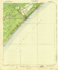
~ Myrtle Beach SC topo map, 1:62500 scale, 15 X 15 Minute, Historical, 1940
Myrtle Beach, South Carolina, USGS topographic map dated 1940.
Includes geographic coordinates (latitude and longitude). This topographic map is suitable for hiking, camping, and exploring, or framing it as a wall map.
Printed on-demand using high resolution imagery, on heavy weight and acid free paper, or alternatively on a variety of synthetic materials.
Topos available on paper, Waterproof, Poly, or Tyvek. Usually shipping rolled, unless combined with other folded maps in one order.
- Product Number: USGS-5388872
- Free digital map download (high-resolution, GeoPDF): Myrtle Beach, South Carolina (file size: 5 MB)
- Map Size: please refer to the dimensions of the GeoPDF map above
- Weight (paper map): ca. 55 grams
- Map Type: POD USGS Topographic Map
- Map Series: HTMC
- Map Verison: Historical
- Cell ID: 58218
- Scan ID: 261903
- Woodland Tint: Yes
- Survey Year: 1937
- Datum: NAD27
- Map Projection: Polyconic
- Map published by United States Geological Survey
- Map Language: English
- Scanner Resolution: 600 dpi
- Map Cell Name: Myrtle Beach
- Grid size: 15 X 15 Minute
- Date on map: 1940
- Map Scale: 1:62500
- Geographical region: South Carolina, United States
Neighboring Maps:
All neighboring USGS topo maps are available for sale online at a variety of scales.
Spatial coverage:
Topo map Myrtle Beach, South Carolina, covers the geographical area associated the following places:
- Fairway Park - Long Bay - Oceanside Village - Plantation Point - Pine Lake Estates - Seaview Place - Ocean Forest - Longleaf - Myrtle Heights - Crystal Lake - Rosewood - Caropine - Oak Park - Surf Pines - Green Bay Park - Ramsey Acres - Socastee - Scott Acres - Pinelands - Dogwood - Surfside Beach - Hurl Rocks - Tarpon Bay - Deerfield Plantation - Springmaid Beach - Platt Spring - Stalvey - Cimerron Plantation South - Forest Dunes - Long Bay Estates - Villa Woods - Midway - Myrtle Beach - Benton Park - Woodland Park - East Chester - Lake Shore - Owens - Ocean Lakes - Cane Patch - Yaupon Circle - Brookgate - Washington Park - Oakland Heights - Hunter Fields - Myrtle Ridge - Highlands - Westwood Estates - Konig - Prestwick - Withers Heights - Pebble Beach - Deer Track Villas - Seacroft - Lakewood - Blynn Acres - Cypress Creek - Forestbrook - The Landing at Plantation Point - Myrtle Heights - Watergate - Pine Island
- Map Area ID: AREA33.7533.5-79-78.75
- Northwest corner Lat/Long code: USGSNW33.75-79
- Northeast corner Lat/Long code: USGSNE33.75-78.75
- Southwest corner Lat/Long code: USGSSW33.5-79
- Southeast corner Lat/Long code: USGSSE33.5-78.75
- Northern map edge Latitude: 33.75
- Southern map edge Latitude: 33.5
- Western map edge Longitude: -79
- Eastern map edge Longitude: -78.75


