
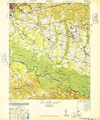
~ Hopkins SC topo map, 1:62500 scale, 15 X 15 Minute, Historical, 1948
Hopkins, South Carolina, USGS topographic map dated 1948.
Includes geographic coordinates (latitude and longitude). This topographic map is suitable for hiking, camping, and exploring, or framing it as a wall map.
Printed on-demand using high resolution imagery, on heavy weight and acid free paper, or alternatively on a variety of synthetic materials.
Topos available on paper, Waterproof, Poly, or Tyvek. Usually shipping rolled, unless combined with other folded maps in one order.
- Product Number: USGS-5388810
- Free digital map download (high-resolution, GeoPDF): Hopkins, South Carolina (file size: 9 MB)
- Map Size: please refer to the dimensions of the GeoPDF map above
- Weight (paper map): ca. 55 grams
- Map Type: POD USGS Topographic Map
- Map Series: HTMC
- Map Verison: Historical
- Cell ID: 55474
- Scan ID: 261871
- Woodland Tint: Yes
- Aerial Photo Year: 1943
- Field Check Year: 1943
- Datum: NAD27
- Map Projection: Transverse Mercator
- Map published by United States Army Corps of Engineers
- Map published by United States Army
- Map Language: English
- Scanner Resolution: 600 dpi
- Map Cell Name: Hopkins
- Grid size: 15 X 15 Minute
- Date on map: 1948
- Map Scale: 1:62500
- Geographical region: South Carolina, United States
Neighboring Maps:
All neighboring USGS topo maps are available for sale online at a variety of scales.
Spatial coverage:
Topo map Hopkins, South Carolina, covers the geographical area associated the following places:
- Sandy Run - Deer Ridge Farms - Lee Hills - Millwood - Starlite - Eastmont - Harmon Estates - Capitol View - Mountain Brook - Green Lake Estates - Rosewood - Childs - Saint Marks Wood - Pine Lake - Washington Park - Quail Hills - Hazelwood Acres - Heathwood - Gadsden - Eastway Park - Yorkshire - Hampton Ridge - Dominion Hills - Bruner - Brandon Hills - Hampton Trace - Pinewood - Galaxy - Gordon Springs - Meadowfield - Sims - San Marco Estates - Swandale - Congaree - Village Bond - Valencia Heights - Padgett Acres - Bluff Estates - Burnside East - Independents - Charlestowne - Mill Creek Estates - Strathaven Forest - Heritage Woods - Oak Grove - Quail Creek - Berkeley Forest - Lykes - Bendemeer - Pennington Acres - Weston - Woodhill Estates - Knollwood - Brandon Acres - Horrel Hill - Hopkins
- Map Area ID: AREA3433.75-81-80.75
- Northwest corner Lat/Long code: USGSNW34-81
- Northeast corner Lat/Long code: USGSNE34-80.75
- Southwest corner Lat/Long code: USGSSW33.75-81
- Southeast corner Lat/Long code: USGSSE33.75-80.75
- Northern map edge Latitude: 34
- Southern map edge Latitude: 33.75
- Western map edge Longitude: -81
- Eastern map edge Longitude: -80.75


