
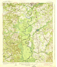
~ Hagood SC topo map, 1:62500 scale, 15 X 15 Minute, Historical, 1938
Hagood, South Carolina, USGS topographic map dated 1938.
Includes geographic coordinates (latitude and longitude). This topographic map is suitable for hiking, camping, and exploring, or framing it as a wall map.
Printed on-demand using high resolution imagery, on heavy weight and acid free paper, or alternatively on a variety of synthetic materials.
Topos available on paper, Waterproof, Poly, or Tyvek. Usually shipping rolled, unless combined with other folded maps in one order.
- Product Number: USGS-5388798
- Free digital map download (high-resolution, GeoPDF): Hagood, South Carolina (file size: 8 MB)
- Map Size: please refer to the dimensions of the GeoPDF map above
- Weight (paper map): ca. 55 grams
- Map Type: POD USGS Topographic Map
- Map Series: HTMC
- Map Verison: Historical
- Cell ID: 54979
- Scan ID: 261865
- Woodland Tint: Yes
- Survey Year: 1934
- Datum: NAD
- Map Projection: Polyconic
- Map published by United States Geological Survey
- Map Language: English
- Scanner Resolution: 600 dpi
- Map Cell Name: Hagood
- Grid size: 15 X 15 Minute
- Date on map: 1938
- Map Scale: 1:62500
- Geographical region: South Carolina, United States
Neighboring Maps:
All neighboring USGS topo maps are available for sale online at a variety of scales.
Spatial coverage:
Topo map Hagood, South Carolina, covers the geographical area associated the following places:
- Beaver Creek - Pecan Grove - Du Bose Park - Thunderwoods - Spears Creek - Leesburg - Cantys Lane - State Farm (historical) - Sandwood Hills - Hagood - Cedar Creek - Spring Village - Paint Hill - Four Seasons - Hammond - Gettysburg - Pine Land - Dinkins Mill - Ellerbee (historical) - Hermitage Mill - Pine Mark - Pepper Ridge - The Groves - McCaskill - English (historical) - Lugoff - Stockton (historical) - Godgold Subdivision - Woodland Forest - Camden - Tickle Hill - Pecan Orchard - Ellerbee (historical) - Happy Home Subdivision - Deloach (historical) - Mayfield Acres - Boykin - Horatio - Meadow View - Ellerbees Mill - Rembert - McCrearys Quarter (historical) - Kellytown - Green Valley - Sanders Corner
- Map Area ID: AREA34.2534-80.75-80.5
- Northwest corner Lat/Long code: USGSNW34.25-80.75
- Northeast corner Lat/Long code: USGSNE34.25-80.5
- Southwest corner Lat/Long code: USGSSW34-80.75
- Southeast corner Lat/Long code: USGSSE34-80.5
- Northern map edge Latitude: 34.25
- Southern map edge Latitude: 34
- Western map edge Longitude: -80.75
- Eastern map edge Longitude: -80.5


