
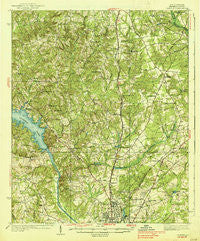
~ Camden SC topo map, 1:62500 scale, 15 X 15 Minute, Historical, 1938
Camden, South Carolina, USGS topographic map dated 1938.
Includes geographic coordinates (latitude and longitude). This topographic map is suitable for hiking, camping, and exploring, or framing it as a wall map.
Printed on-demand using high resolution imagery, on heavy weight and acid free paper, or alternatively on a variety of synthetic materials.
Topos available on paper, Waterproof, Poly, or Tyvek. Usually shipping rolled, unless combined with other folded maps in one order.
- Product Number: USGS-5388678
- Free digital map download (high-resolution, GeoPDF): Camden, South Carolina (file size: 10 MB)
- Map Size: please refer to the dimensions of the GeoPDF map above
- Weight (paper map): ca. 55 grams
- Map Type: POD USGS Topographic Map
- Map Series: HTMC
- Map Verison: Historical
- Cell ID: 52049
- Scan ID: 261799
- Woodland Tint: Yes
- Survey Year: 1935
- Datum: NAD
- Map Projection: Polyconic
- Map published by United States Geological Survey
- Map Language: English
- Scanner Resolution: 600 dpi
- Map Cell Name: Camden
- Grid size: 15 X 15 Minute
- Date on map: 1938
- Map Scale: 1:62500
- Geographical region: South Carolina, United States
Neighboring Maps:
All neighboring USGS topo maps are available for sale online at a variety of scales.
Spatial coverage:
Topo map Camden, South Carolina, covers the geographical area associated the following places:
- Gaston Mill - Spalding (historical) - Dusty Bend - Kirkley Mill - Shepard - Flat Rock - Fairfax - Kirkwood - Knights Hill - Pine Creek - Forest Heights - Shamokin - Valley Park - Norris Heights - Cool Springs - Hyco - Barfield Mill - Sunnyhill - Grannys Quarter (historical) - Sandy Springs - Lockhart Oil Field - Lafayette Village - Branham Heights - Kirkland - Edgewood - Hillsdale - Westville - Bee Tree (historical) - Rabon Crossroads - Clyburn - Millbank (historical) - Kirkover Hills - Cantey - Spring Lake - White Gardens - Dekalb - Arrowwood - Windsor Heights - Peckwoods - Log Town (historical) - Red Hill - Jordan Mill
- Map Area ID: AREA34.534.25-80.75-80.5
- Northwest corner Lat/Long code: USGSNW34.5-80.75
- Northeast corner Lat/Long code: USGSNE34.5-80.5
- Southwest corner Lat/Long code: USGSSW34.25-80.75
- Southeast corner Lat/Long code: USGSSE34.25-80.5
- Northern map edge Latitude: 34.5
- Southern map edge Latitude: 34.25
- Western map edge Longitude: -80.75
- Eastern map edge Longitude: -80.5


