
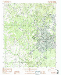
~ Rock Hill West SC topo map, 1:24000 scale, 7.5 X 7.5 Minute, Historical, 1984, updated 1985
Rock Hill West, South Carolina, USGS topographic map dated 1984.
Includes geographic coordinates (latitude and longitude). This topographic map is suitable for hiking, camping, and exploring, or framing it as a wall map.
Printed on-demand using high resolution imagery, on heavy weight and acid free paper, or alternatively on a variety of synthetic materials.
Topos available on paper, Waterproof, Poly, or Tyvek. Usually shipping rolled, unless combined with other folded maps in one order.
- Product Number: USGS-5388132
- Free digital map download (high-resolution, GeoPDF): Rock Hill West, South Carolina (file size: 15 MB)
- Map Size: please refer to the dimensions of the GeoPDF map above
- Weight (paper map): ca. 55 grams
- Map Type: POD USGS Topographic Map
- Map Series: HTMC
- Map Verison: Historical
- Cell ID: 38241
- Scan ID: 261500
- Imprint Year: 1985
- Woodland Tint: Yes
- Visual Version Number: 2
- Aerial Photo Year: 1979
- Edit Year: 1984
- Field Check Year: 1980
- Datum: NAD27
- Map Projection: Lambert Conformal Conic
- Map published by United States Geological Survey
- Map Language: English
- Scanner Resolution: 600 dpi
- Map Cell Name: Rock Hill West
- Grid size: 7.5 X 7.5 Minute
- Date on map: 1984
- Map Scale: 1:24000
- Geographical region: South Carolina, United States
Neighboring Maps:
All neighboring USGS topo maps are available for sale online at a variety of scales.
Spatial coverage:
Topo map Rock Hill West, South Carolina, covers the geographical area associated the following places:
- Trexler Acres - Ebenezer - Kimberly Woods - Botany Woods - Swan Meadows - Greenfield Acres - Rawlinson Woods - Winthrop Heights - Kenilworth Acres - Quail Run - Steele Crossing - Rock Hill - Woodbridge - Mexico - Clinton Park - Whispering Hills - Belle Meade - Oldwoods - Avondale Terrace - Shadowbrook - Country Oaks - Wood Forest - Camelot Woods - Quiet Acres - Willow Acres - Devonshire - Old Farm - Woodwind - Wintercrest - Clubside Estates - Oakdale Acres - Flint Hill - Glenwood Acres - Coventry Estates - Sedgefield - Monterey Hills - Boyd Hill - Rawlinson Acres - Ragin Estates - Fairlawn - Miller Crossing - Stoneybrook Estates - Meadow Lakes - Belair Acres - Cedar Forest Acres - Beaty Estates - Southland Park - Brookwood - Squire Estates - Red Oaks - Pineridge - Cato Estates - Sunset Acres - Country Club Estates - Lakeview Acres - Forest Hills - Church Hill Heights - Oakdale - Matthews Estates - Newport - Laney Terrace - College Farms - Westerwood Acres - Old Point Station - Heatherwood - Shiland Hills - Cedar Grove Park - Oakwood Acres
- Map Area ID: AREA3534.875-81.125-81
- Northwest corner Lat/Long code: USGSNW35-81.125
- Northeast corner Lat/Long code: USGSNE35-81
- Southwest corner Lat/Long code: USGSSW34.875-81.125
- Southeast corner Lat/Long code: USGSSE34.875-81
- Northern map edge Latitude: 35
- Southern map edge Latitude: 34.875
- Western map edge Longitude: -81.125
- Eastern map edge Longitude: -81


