
~ North Augusta SC topo map, 1:24000 scale, 7.5 X 7.5 Minute, Historical, 1964, updated 1981
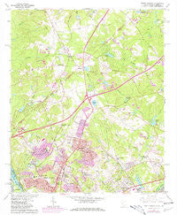
North Augusta, South Carolina, USGS topographic map dated 1964.
Includes geographic coordinates (latitude and longitude). This topographic map is suitable for hiking, camping, and exploring, or framing it as a wall map.
Printed on-demand using high resolution imagery, on heavy weight and acid free paper, or alternatively on a variety of synthetic materials.
Topos available on paper, Waterproof, Poly, or Tyvek. Usually shipping rolled, unless combined with other folded maps in one order.
- Product Number: USGS-5387862
- Free digital map download (high-resolution, GeoPDF): North Augusta, South Carolina (file size: 14 MB)
- Map Size: please refer to the dimensions of the GeoPDF map above
- Weight (paper map): ca. 55 grams
- Map Type: POD USGS Topographic Map
- Map Series: HTMC
- Map Verison: Historical
- Cell ID: 32307
- Scan ID: 261365
- Imprint Year: 1981
- Woodland Tint: Yes
- Photo Revision Year: 1980
- Aerial Photo Year: 1977
- Edit Year: 1980
- Field Check Year: 1965
- Datum: NAD27
- Map Projection: Polyconic
- Map published by United States Geological Survey
- Map Language: English
- Scanner Resolution: 600 dpi
- Map Cell Name: North Augusta
- Grid size: 7.5 X 7.5 Minute
- Date on map: 1964
- Map Scale: 1:24000
- Geographical region: South Carolina, United States
Neighboring Maps:
All neighboring USGS topo maps are available for sale online at a variety of scales.
Spatial coverage:
Topo map North Augusta, South Carolina, covers the geographical area associated the following places:
- Summer Hill - Heathwood Park - Crestland - Fairview Gardens - Brogden - Carolina Terrace - Wellington - Pineview Estates - Lynnhurst - Augusta View Heights - Shannon - The Colony - Woodlawn - Belclear - Willow Springs Park - Big Cone Ridge - Smithfield - Horse Creek - Pinewood Plantation - Ridgecrest - Pinecrest - Bahama Heights - Coventry - Ascaga Heights - Crestdale - Woodridge - Hammond Hills - Audubon Homes - Brierfield - Lakewood - North Augusta - Martintowne - Sweetwater - Pine Valley - Pine and Oak Woods - Barclay Estates - Belvedere - Laurel Lakes - Heatherwood - Rose Hill - Murphys Estates - Edgefield Heights - Bradleyville - Pinehurst - Huntington Estates - Brookgreen - Lake Forest Estates - Lakewood - Windtree - Bonnie Glen - Sandlewood - Greenfield - Country Place
- Map Area ID: AREA33.62533.5-82-81.875
- Northwest corner Lat/Long code: USGSNW33.625-82
- Northeast corner Lat/Long code: USGSNE33.625-81.875
- Southwest corner Lat/Long code: USGSSW33.5-82
- Southeast corner Lat/Long code: USGSSE33.5-81.875
- Northern map edge Latitude: 33.625
- Southern map edge Latitude: 33.5
- Western map edge Longitude: -82
- Eastern map edge Longitude: -81.875


