
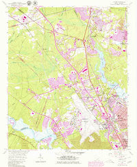
~ Ladson SC topo map, 1:24000 scale, 7.5 X 7.5 Minute, Historical, 1958, updated 1980
Ladson, South Carolina, USGS topographic map dated 1958.
Includes geographic coordinates (latitude and longitude). This topographic map is suitable for hiking, camping, and exploring, or framing it as a wall map.
Printed on-demand using high resolution imagery, on heavy weight and acid free paper, or alternatively on a variety of synthetic materials.
Topos available on paper, Waterproof, Poly, or Tyvek. Usually shipping rolled, unless combined with other folded maps in one order.
- Product Number: USGS-5387562
- Free digital map download (high-resolution, GeoPDF): Ladson, South Carolina (file size: 12 MB)
- Map Size: please refer to the dimensions of the GeoPDF map above
- Weight (paper map): ca. 55 grams
- Map Type: POD USGS Topographic Map
- Map Series: HTMC
- Map Verison: Historical
- Cell ID: 24236
- Scan ID: 261209
- Imprint Year: 1980
- Woodland Tint: Yes
- Photo Revision Year: 1979
- Aerial Photo Year: 1977
- Edit Year: 1979
- Survey Year: 1958
- Datum: NAD27
- Map Projection: Polyconic
- Map published by United States Geological Survey
- Map Language: English
- Scanner Resolution: 600 dpi
- Map Cell Name: Ladson
- Grid size: 7.5 X 7.5 Minute
- Date on map: 1958
- Map Scale: 1:24000
- Geographical region: South Carolina, United States
Neighboring Maps:
All neighboring USGS topo maps are available for sale online at a variety of scales.
Spatial coverage:
Topo map Ladson, South Carolina, covers the geographical area associated the following places:
- Archdale - Wildwood - Runnymede - Poppenheim Crossing - Colony North - Highland Park - Tenmile - Stratton Capers - Pepperhill - Deerwood Heights - Ashley Heights - Ladson Village - Wilsonville - The Farms - Belvedere - Goose Creek Heights - Liberty Park - Harbour Lake - Northwood Estates - Forestdale - Willowbrook - The Oaks - Camelot Village - Pinewood Vista - Highland Terrace - Lambs - Riverbend - Goose Creek - Pineview Hills - Singing Pines - Pepperidge - Deer Park - Ararat - Russelldale - Otranto - Dorchester Manor - Shady Grove - Highlands - West Greenview Acres - Midland Park - Maple Ridge - Hunley Park - Forest Hills - Liberty Hills - Pleasant Hills - Ladson - Oak Grove - Sedgefield - University Park - Woodstock - Ferndale - Hanahan - Saint James Estates - Berkeley Hills
- Map Area ID: AREA3332.875-80.125-80
- Northwest corner Lat/Long code: USGSNW33-80.125
- Northeast corner Lat/Long code: USGSNE33-80
- Southwest corner Lat/Long code: USGSSW32.875-80.125
- Southeast corner Lat/Long code: USGSSE32.875-80
- Northern map edge Latitude: 33
- Southern map edge Latitude: 32.875
- Western map edge Longitude: -80.125
- Eastern map edge Longitude: -80


