
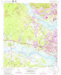
~ Johns Island SC topo map, 1:24000 scale, 7.5 X 7.5 Minute, Historical, 1958, updated 1979
Johns Island, South Carolina, USGS topographic map dated 1958.
Includes geographic coordinates (latitude and longitude). This topographic map is suitable for hiking, camping, and exploring, or framing it as a wall map.
Printed on-demand using high resolution imagery, on heavy weight and acid free paper, or alternatively on a variety of synthetic materials.
Topos available on paper, Waterproof, Poly, or Tyvek. Usually shipping rolled, unless combined with other folded maps in one order.
- Product Number: USGS-5387494
- Free digital map download (high-resolution, GeoPDF): Johns Island, South Carolina (file size: 12 MB)
- Map Size: please refer to the dimensions of the GeoPDF map above
- Weight (paper map): ca. 55 grams
- Map Type: POD USGS Topographic Map
- Map Series: HTMC
- Map Verison: Historical
- Cell ID: 22676
- Scan ID: 261170
- Imprint Year: 1979
- Woodland Tint: Yes
- Photo Revision Year: 1979
- Aerial Photo Year: 1977
- Edit Year: 1979
- Survey Year: 1958
- Datum: NAD27
- Map Projection: Polyconic
- Map published by United States Geological Survey
- Map Language: English
- Scanner Resolution: 600 dpi
- Map Cell Name: Johns Island
- Grid size: 7.5 X 7.5 Minute
- Date on map: 1958
- Map Scale: 1:24000
- Geographical region: South Carolina, United States
Neighboring Maps:
All neighboring USGS topo maps are available for sale online at a variety of scales.
Spatial coverage:
Topo map Johns Island, South Carolina, covers the geographical area associated the following places:
- Dupont Station - Stone Park - Bon Aire - Oakland - Stono Station - Fort Bull - Orleans Woods - Ashley Harbor - Marsh Cove - Limehouse Station - Wando Gardens - Fetteressa - Drayton - Wappoo Shores - Shadowmoss - Ashley Hall Manor - Pierpont - Cohen Hill - Parsonage Point - Covington Hills - Sandy - Green Grove - Plantation Estates - Joshua - Magnolia Ranch - Pinecrest - Shell Point - Edgewater Park - Orange Grove Estates - Johns Island - Huntington Woods - Ashley Acres - Oak Ridge - Myrtle Grove - Hickory Hall Plantation - Evanston Estates - Forest Lakes - Bennett - Long Branch Estates - Faber Place - Hickory Hill - Glyn Terrace - Capri Isles - Melrose - Sylvia Lane - Heathwood - Essex Village - Forest Acres West - Wando Woods - Orleans Estates - Saint Andrews Heights - Castlewood - Ponderosa - Parkdale - Springfield - Indigo Point - Brentwood - Murry Hill - Red Top - Sylecope - Church Creek - Ashley Villas - Harrison Acres - Dogwood Gardens - North Pine Point - Sherwood Forest - Greenwood Park
- Map Area ID: AREA32.87532.75-80.125-80
- Northwest corner Lat/Long code: USGSNW32.875-80.125
- Northeast corner Lat/Long code: USGSNE32.875-80
- Southwest corner Lat/Long code: USGSSW32.75-80.125
- Southeast corner Lat/Long code: USGSSE32.75-80
- Northern map edge Latitude: 32.875
- Southern map edge Latitude: 32.75
- Western map edge Longitude: -80.125
- Eastern map edge Longitude: -80


